IMAGES TAKEN NEAR TO
Broad Street, WOLVERHAMPTON, WV1 1JA
Introduction
This page details the photographs taken nearby to Broad Street, WV1 1JA by members of the Geograph project.
The Geograph project started in 2005 with the aim of publishing, organising and preserving representative images for every square kilometre of Great Britain, Ireland and the Isle of Man.

There are currently over 7.5m images from over14,400 individuals and you can help contribute to the project by visiting https://www.geograph.org.uk
Image Map
Images are licensed for reuse under creativecommons.org/licenses/by-sa/2.0
Notes
- Clicking on the map will re-center to the selected point.
- The higher the marker number, the further away the image location is from the centre of the postcode.
Image Listing (1434 Images Found)
Images are licensed for reuse under creativecommons.org/licenses/by-sa/2.0
Image
Details
Distance
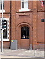
1
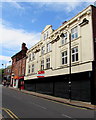
Vacant Broad Street premises, Wolverhampton
In September 2016, the Redstones board on the premises states that planning
permission has been approved for 22 bedsits and 3 large commercial units.
Image: © Jaggery
Taken: 17 Sep 2016
0.01 miles
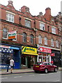
2
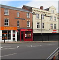
Caspian Kebabs & Pizza, Wolverhampton
City centre takeaway at 1 Broad Street.
Image: © Jaggery
Taken: 17 Sep 2016
0.01 miles
3
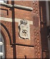
Emblem of the South Staffordshire Regiment
Detail of the emblems on the Drill Hall. Image
The South Staffordshire Regiment was raised by Colonel Luke Lillingston at the Kings Head in Lichfield in 1705. Originally they were known as ‘Lillingston’s Regiment’ and in 1751 became the ‘38th of Foot’. After service in Ireland they spent many years in the West Indies before fighting in the American War of Independence. In 1772 the 38th added the name the ‘1st Staffordshires’ when county designations were attached to aid recruitment. For the north of the county the 64th added the name the ‘2nd Staffordshires’. Shortly afterwards both regiments adopted the Stafford Knot as their emblem.
The Stafford Knot was a badge of the Earl of Stafford, later Duke of Buckingham in the 15th century. Its origins go back to his kinswoman Joan, Lady of Wake a descendant of Hereward the Wake.
The South Staffs Knot is surmounted by a crown. The North Staffs Knot has Prince of Wales Feathers
Image: © John M
Taken: 29 Mar 2009
0.01 miles
4
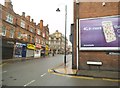
Thornley Street View
The view up Broad Street in Wolverhampton.
Image: © Gordon Griffiths
Taken: 25 Nov 2015
0.01 miles
5
The Hog's Head in Wolverhampton
Broad Street is off to the right.
Image: © Roger D Kidd
Taken: 29 Mar 2014
0.01 miles
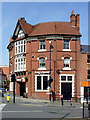
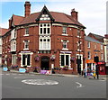
6
The Hog's Head in Wolverhampton
This imposing red-brick public house is on the corner of Broad Street and Stafford Street.
Image: © Roger D Kidd
Taken: 29 Mar 2014
0.01 miles
7
Aunt Sally's Caribbean Restaurant, Broad Street, Wolverhampton
Aunt Sally's nameboard shows the yellow and green colours of the national flag of Jamaica.
Image: © Jaggery
Taken: 17 Sep 2016
0.01 miles
8

Thornley Street towards Broad Street, Wolverhampton
From the corner of Whitmore Street.
Image: © Jaggery
Taken: 17 Sep 2016
0.02 miles
9
Vine Inn
The original name of this pub, now the Hog's Head http://www.geograph.org.uk/photo/2810322, can be seen in this fine terracotta panel over a bricked-up former doorway. The vertical pilaster strips of terracotta are a noteworthy feature, and have been used to provide continuity through the excellent article http://www.localhistory.scit.wlv.ac.uk/interesting/terracotta/terrafront.htm on terracotta in Wolverhampton in the local history society's website.
Image: © Alan Murray-Rust
Taken: 14 Feb 2012
0.02 miles
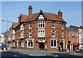
10
Hog's Head Wolverhampton
Redbrick pub at 186 Stafford Street, on the corner of Broad Street.
Image: © Jaggery
Taken: 17 Sep 2016
0.02 miles