IMAGES TAKEN NEAR TO
Argil Close, WOLVERHAMPTON, WV11 3TL
Introduction
This page details the photographs taken nearby to Argil Close, WV11 3TL by members of the Geograph project.
The Geograph project started in 2005 with the aim of publishing, organising and preserving representative images for every square kilometre of Great Britain, Ireland and the Isle of Man.

There are currently over 7.5m images from over14,400 individuals and you can help contribute to the project by visiting https://www.geograph.org.uk
Image Map
Images are licensed for reuse under creativecommons.org/licenses/by-sa/2.0
Notes
- Clicking on the map will re-center to the selected point.
- The higher the marker number, the further away the image location is from the centre of the postcode.
Image Listing (19 Images Found)
Images are licensed for reuse under creativecommons.org/licenses/by-sa/2.0
Image
Details
Distance
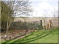
1
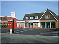
'One Stop' on Linthouse Lane
Former Noah's Ark PH
Image: © John M
Taken: 14 Mar 2016
0.04 miles
2
Dead Pheasant in Wood End
The Pheasant Inn seems to have met the fate of many local pubs.
Image: © John M
Taken: 5 Sep 2009
0.07 miles
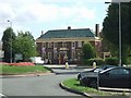
3
Long Knowle Community Hub
A polling station for the EU Referendum.
Image: © John M
Taken: 23 Jun 2016
0.09 miles
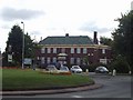
4
Pheasant Inn - Wood End
Public House at roundabout corner of Linthouse Lane and Wood End Road.
Image: © John M
Taken: 3 Sep 2006
0.09 miles
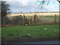
5
Path off Linthouse Lane
Still the edge of the urban area and consequently the Wolverhampton council area. If its growing stuff it is probably in Staffordshire Council's area.
Image: © Richard Webb
Taken: 13 Apr 2016
0.14 miles
6
Monarch's Way Wednesfield
The Way at Linthouse Lane.
Image: © Gordon Griffiths
Taken: 10 Jan 2008
0.14 miles
7
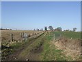
Track to Prestwood Farm
Farmland in the narrow green belt north-east of Wolverhampton.
Image: © John M
Taken: 29 Mar 2009
0.14 miles
8
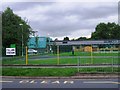
Wood End Primary School
The new school buildings opened last year.
A polling station for the EU Referendum.
Image: © John M
Taken: 23 Jun 2016
0.15 miles
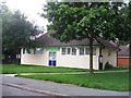
9
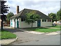
Long Knowle Library
Typical district library built for Wednesfield UDC before incorporation into Wolverhampton. Probably dated late 1950s and now extended to include community facilities.
Image: © John M
Taken: 3 Sep 2006
0.15 miles
10
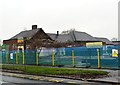
Demolition of Wood End Primary School
The two-storey 1960 block was demolished at the start of the year. Now is the turn of the original 1938 school. A new £2.5M school has been constructed on the playing field. My brother and I were pupils at the school in the 1960s.
Image: © John M
Taken: 13 Dec 2015
0.15 miles