IMAGES TAKEN NEAR TO
Satellite Industrial Park, Neachells Lane, WOLVERHAMPTON, WV11 3PQ
Introduction
This page details the photographs taken nearby to Satellite Industrial Park, Neachells Lane, WV11 3PQ by members of the Geograph project.
The Geograph project started in 2005 with the aim of publishing, organising and preserving representative images for every square kilometre of Great Britain, Ireland and the Isle of Man.

There are currently over 7.5m images from over14,400 individuals and you can help contribute to the project by visiting https://www.geograph.org.uk
Image Map
Images are licensed for reuse under creativecommons.org/licenses/by-sa/2.0
Notes
- Clicking on the map will re-center to the selected point.
- The higher the marker number, the further away the image location is from the centre of the postcode.
Image Listing (43 Images Found)
Images are licensed for reuse under creativecommons.org/licenses/by-sa/2.0
Image
Details
Distance
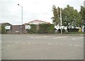
1
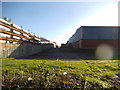
Path View
The view of Industrial Units off the A4124 in Wednesfield, Wolverhampton.
Image: © Gordon Griffiths
Taken: 9 Feb 2016
0.02 miles
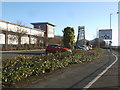
2
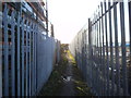
Factory Alley
The view of the alley off the A4124 in Wednesfield, Wolverhampton.
Image: © Gordon Griffiths
Taken: 9 Feb 2016
0.05 miles
3
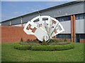
Lock Mechanism
Statue of lock outside Chubb Custodial Services off Wednesfield Way. Lockmakers Chubb, Eaton and Yale are now all owned by a Swedish company and most of the products are sourced from China.
Image: © John M
Taken: 15 Sep 2006
0.06 miles
4
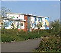
Gem Centre near Wednesfield Way
A colourful new centre for the community health, social care and education services for children with special needs.
Image: © John M
Taken: 15 Sep 2006
0.06 miles
5
Wednesfield Way Path
The view of the footpath off the A4124 in Wednesfield, Wolverhampton.
Image: © Gordon Griffiths
Taken: 7 Oct 2015
0.07 miles
6
Air Space Car Park
The view off Wells Lane in Wednesfield, Wolverhampton.
Image: © Gordon Griffiths
Taken: 9 Feb 2016
0.07 miles
7
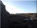
Building Land
The view of land off the A4124 in Wednesfield, Wolverhampton.
Image: © Gordon Griffiths
Taken: 9 Feb 2016
0.07 miles
8
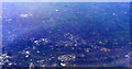
Wolverhampton from the air
Planetary Trading Estate is in the lower centre of the photo. Dunstall Park racecourse is to the right of centre. Viewed from a Heathrow bound flight from Glasgow.
Image: © Thomas Nugent
Taken: 10 Apr 2011
0.08 miles
9
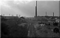
Track bed of the closed Walsall - Wolverhampton line at the site of the former Wednesfield Station.
Track bed of the closed Walsall - Wolverhampton line at the site of the former Wednesfield Station looking towards Wolverhampton. 1978. The line was still in use at this time as far as the Weldless Steel Tube Factory. Taken from Neachells Lane Bridge. The trackbed is now part of Wednesfield - Wolverhampton Road.
Image: © Tim Marshall
Taken: 23 Oct 1978
0.09 miles
10
Neachells Lane Island
The view from Wednesfield Way in a Industrial area of Wednesfield.
Image: © Gordon Griffiths
Taken: 8 Aug 2015
0.09 miles