IMAGES TAKEN NEAR TO
Lawrence Avenue, WOLVERHAMPTON, WV11 3PF
Introduction
This page details the photographs taken nearby to Lawrence Avenue, WV11 3PF by members of the Geograph project.
The Geograph project started in 2005 with the aim of publishing, organising and preserving representative images for every square kilometre of Great Britain, Ireland and the Isle of Man.

There are currently over 7.5m images from over14,400 individuals and you can help contribute to the project by visiting https://www.geograph.org.uk
Image Map
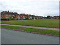
Images are licensed for reuse under creativecommons.org/licenses/by-sa/2.0
Notes
- Clicking on the map will re-center to the selected point.
- The higher the marker number, the further away the image location is from the centre of the postcode.
Image Listing (28 Images Found)
Images are licensed for reuse under creativecommons.org/licenses/by-sa/2.0
Image
Details
Distance
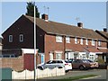
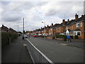
2
Colman Avenue, Perry Hall (2)
Seen from the junction with Whittingham Grove (left).
Image: © Richard Vince
Taken: 22 Sep 2017
0.07 miles
3
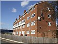
Council Housing - Castlebridge Estate
Wednesfield UDC developed the Castlebridge Estate in the early 1950s. This block comprises sixteen flats.
Image: © John M
Taken: 19 Mar 2011
0.08 miles
4
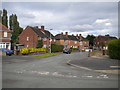
North end of Lawrence Avenue, Perry Hall
Seen from Colman Avenue.
Image: © Richard Vince
Taken: 22 Sep 2017
0.08 miles
5
Council Housing - Merrick Road
Post war housing built for Wednesfield UDC on the early 1950s Castlebridge Estate.
Image: © John M
Taken: 19 Mar 2011
0.10 miles
6
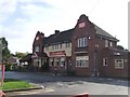
Albion Hotel - Lichfield Road
Locally listed inter-war public house in residential area. The weathboarding to first floor is not an original feature. The pub is likely to get a coat of white paint when Sizzling Pub Co's team get to work on it.
Image: © John M
Taken: 23 Oct 2010
0.10 miles
7
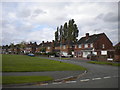
Eastern part of Lawrence Avenue, Perry Hall
Lawrence Avenue splits into two near its north end, with the open space partially visible on the left occupying the space between the two halves.
Image: © Richard Vince
Taken: 22 Sep 2017
0.11 miles
8
Western part of Lawrence Avenue, Perry Hall
Lawrence Avenue splits into two near its north end, with the open space visible on the right occupying the space between the two halves.
Image: © Richard Vince
Taken: 22 Sep 2017
0.11 miles
9
Colman Avenue, Perry Hall (1)
Seen from the junction with Perry Hall Road; the railings are there due to the presence of Perry Hall Primary School (out of frame to the left).
Image: © Richard Vince
Taken: 22 Sep 2017
0.12 miles
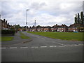
10
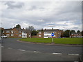
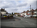
Approaching Stubby Lane roundabout, Perry Hall
Seen from the end of Perry Hall Road.
Image: © Richard Vince
Taken: 22 Sep 2017
0.13 miles