IMAGES TAKEN NEAR TO
Lichfield Road, WOLVERHAMPTON, WV11 3HX
Introduction
This page details the photographs taken nearby to Lichfield Road, WV11 3HX by members of the Geograph project.
The Geograph project started in 2005 with the aim of publishing, organising and preserving representative images for every square kilometre of Great Britain, Ireland and the Isle of Man.

There are currently over 7.5m images from over14,400 individuals and you can help contribute to the project by visiting https://www.geograph.org.uk
Image Map
Images are licensed for reuse under creativecommons.org/licenses/by-sa/2.0
Notes
- Clicking on the map will re-center to the selected point.
- The higher the marker number, the further away the image location is from the centre of the postcode.
Image Listing (30 Images Found)
Images are licensed for reuse under creativecommons.org/licenses/by-sa/2.0
Image
Details
Distance
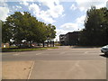
1
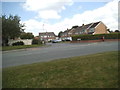
Wem Gardens
The view from Lichfield Road in Wednesfield.
Image: © Gordon Griffiths
Taken: 8 Aug 2015
0.04 miles
2
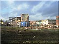
Demolition of Jennie Lee Centre formerly Ward's Bridge Secondary Modern
Former school site to be redeveloped by Taylor Wimpey for 217 homes.
It rather begs the question as to why it took from school closure in 1989 until 2013 to accept the obvious use for this surplus school site. The school site was maintained for 20 years with use by a few keep fit and sports clubs and some sports pitches.
Image: © John M
Taken: 15 Jan 2014
0.06 miles
3
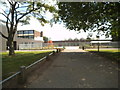
School View
The view of Wednesfield High School.
Image: © Gordon Griffiths
Taken: 8 Aug 2015
0.10 miles
4
Jennie Lee Centre
This was originally Wards Bridge Secondary Modern School. The centre is named after Jennie Lee who was the MP (1945-1970) for the Cannock constituency that included Wednesfield. Jennie Lee was married to Aneurin Bevan and was instrumental in the founding of the Open University by Harold Wilson's administration.
Image: © John M
Taken: 1 Oct 2006
0.12 miles
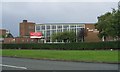
5
School Entrance
The view of Wednesfield High School from Lichfield Road in Wednesfield.
Image: © Gordon Griffiths
Taken: 8 Aug 2015
0.13 miles
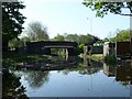
6
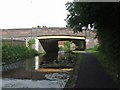
Wyley & Essington Canal - Ward's Bridge
Typical of a number of bridges over the Wednesfield section of canal.
Image: © John M
Taken: 10 Aug 2008
0.14 miles
7

New houses off Asheridge Close, Wednesfield
On the east bank of the Wyrley & Essington Canal.
Image: © Christine Johnstone
Taken: 7 May 2018
0.14 miles
8
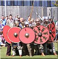
Shield Wall
The scene on Wednesfield High School field of a re-enactment of the Battle of Wodensfield, a significant battle in British history. The battle took place in August 910 AD and saw the Anglo Saxons defeat the Viking Danes of Northumberland in Woden (Wednesfield).
Image: © Gordon Griffiths
Taken: 8 Aug 2015
0.14 miles
9
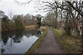
Wyrley & Essington Canal towards Wards Bridge
Image: © Ian S
Taken: 16 Dec 2021
0.15 miles
10
Wards Bridge, from the north
Carrying the Lichfield Road [B4484] over the Wyrley & Essington Canal.
Image: © Christine Johnstone
Taken: 7 May 2018
0.15 miles