IMAGES TAKEN NEAR TO
Shardlow Road, WOLVERHAMPTON, WV11 3AY
Introduction
This page details the photographs taken nearby to Shardlow Road, WV11 3AY by members of the Geograph project.
The Geograph project started in 2005 with the aim of publishing, organising and preserving representative images for every square kilometre of Great Britain, Ireland and the Isle of Man.

There are currently over 7.5m images from over14,400 individuals and you can help contribute to the project by visiting https://www.geograph.org.uk
Image Map
Images are licensed for reuse under creativecommons.org/licenses/by-sa/2.0
Notes
- Clicking on the map will re-center to the selected point.
- The higher the marker number, the further away the image location is from the centre of the postcode.
Image Listing (17 Images Found)
Images are licensed for reuse under creativecommons.org/licenses/by-sa/2.0
Image
Details
Distance
1
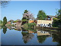
Rocester Avenue back gardens
On the north bank of the Wyrley & Essington Canal.
Image: © Christine Johnstone
Taken: 7 May 2018
0.12 miles
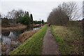
2
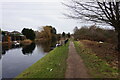
Wyrley & Essington Canal towards Devils Elbow Bridge
Image: © Ian S
Taken: 16 Dec 2021
0.14 miles
3
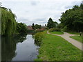
The Essington and Wyrley canal near Wood End
Image: © Richard Law
Taken: 22 Jul 2011
0.15 miles
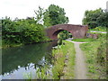
4
Wyrley & Essington Canal at Devils Elbow Bridge
Image: © Ian S
Taken: 16 Dec 2021
0.15 miles
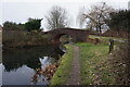
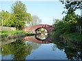
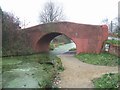
5
Devil's Elbow bridge
Presumably it takes its name from the sharp (for a canal) bend just this side of the bridge.
Image: © Richard Law
Taken: 22 Jul 2011
0.15 miles
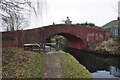
6
Devil's Elbow Bridge, from the south-east
Carrying a public footpath over the Wyrley & Essington Canal.
Image: © Christine Johnstone
Taken: 7 May 2018
0.16 miles
7
Wyrley & Essington Canal at Devils Elbow Bridge
Image: © Ian S
Taken: 16 Dec 2021
0.16 miles
8
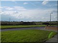
Over the edge
Looking out of Ashmore Park to the block of surviving farmland at Prestwood.
Image: © Richard Webb
Taken: 13 Apr 2016
0.16 miles
9
Wyrley & Essington Canal towards Devils Elbow Bridge
Image: © Ian S
Taken: 16 Dec 2021
0.20 miles
10
Devils Elbow
This bridge over the Wyrley and Essington Canal has been given a shocking pink rendered finish. The Monarch's Way long distance footpath uses the canal towpath.
Image: © John M
Taken: 26 Dec 2006
0.20 miles