IMAGES TAKEN NEAR TO
Warstone Road, WOLVERHAMPTON, WV11 2RZ
Introduction
This page details the photographs taken nearby to Warstone Road, WV11 2RZ by members of the Geograph project.
The Geograph project started in 2005 with the aim of publishing, organising and preserving representative images for every square kilometre of Great Britain, Ireland and the Isle of Man.

There are currently over 7.5m images from over14,400 individuals and you can help contribute to the project by visiting https://www.geograph.org.uk
Image Map
Images are licensed for reuse under creativecommons.org/licenses/by-sa/2.0
Notes
- Clicking on the map will re-center to the selected point.
- The higher the marker number, the further away the image location is from the centre of the postcode.
Image Listing (3 Images Found)
Images are licensed for reuse under creativecommons.org/licenses/by-sa/2.0
Image
Details
Distance
2

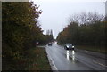
Warstone Road
The A462 passing through what looks like scrubby former industrial land.
Image: © Bill Boaden
Taken: 19 Apr 2019
0.10 miles
3
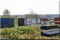
Compound off Warstone Road
The site does not look very active.
Image: © Bill Boaden
Taken: 19 Apr 2019
0.13 miles