IMAGES TAKEN NEAR TO
Springhill View, WOLVERHAMPTON, WV11 2RN
Introduction
This page details the photographs taken nearby to Springhill View, WV11 2RN by members of the Geograph project.
The Geograph project started in 2005 with the aim of publishing, organising and preserving representative images for every square kilometre of Great Britain, Ireland and the Isle of Man.

There are currently over 7.5m images from over14,400 individuals and you can help contribute to the project by visiting https://www.geograph.org.uk
Image Map
Images are licensed for reuse under creativecommons.org/licenses/by-sa/2.0
Notes
- Clicking on the map will re-center to the selected point.
- The higher the marker number, the further away the image location is from the centre of the postcode.
Image Listing (17 Images Found)
Images are licensed for reuse under creativecommons.org/licenses/by-sa/2.0
Image
Details
Distance
1

Long Lane, Essington, February, 1985
Looking towards Newtown.
Image: © Tim Marshall
Taken: 9 Feb 1985
0.03 miles
2
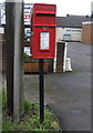
Elizabeth II postbox on Broad Lane, Springhill
Postbox No. WV11 154.
See Image] for context.
Image: © JThomas
Taken: 9 Nov 2019
0.04 miles
3
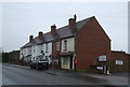
Houses on Broad Lane, Springhill
Showing position of Postbox No. WV11 154.
See Image] for postbox.
Image: © JThomas
Taken: 9 Nov 2019
0.04 miles
4
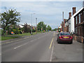
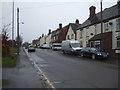
B4210 looking NW from The Why Not at Springhill
Image: © John Firth
Taken: 5 Jun 2011
0.05 miles
5
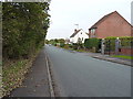
Long Lane, Springhill
This road leads to the intriguingly-named Hobble End; it essentially joins the B4210 to the A34.
Image: © Richard Law
Taken: 16 Oct 2014
0.06 miles

8
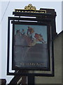
Sign for the Why Not, Springhill
See Image] for context.
Image: © JThomas
Taken: 9 Nov 2019
0.10 miles
9
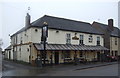
The Why Not, Springhill
On Broad Lane (B4210).
Image: © JThomas
Taken: 9 Nov 2019
0.10 miles
10
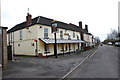
The Why Not in Springhill on the B4210
Image: © Mick Malpass
Taken: 1 Jan 2012
0.10 miles