IMAGES TAKEN NEAR TO
Denmead Drive, WOLVERHAMPTON, WV11 2QS
Introduction
This page details the photographs taken nearby to Denmead Drive, WV11 2QS by members of the Geograph project.
The Geograph project started in 2005 with the aim of publishing, organising and preserving representative images for every square kilometre of Great Britain, Ireland and the Isle of Man.

There are currently over 7.5m images from over14,400 individuals and you can help contribute to the project by visiting https://www.geograph.org.uk
Image Map
Images are licensed for reuse under creativecommons.org/licenses/by-sa/2.0
Notes
- Clicking on the map will re-center to the selected point.
- The higher the marker number, the further away the image location is from the centre of the postcode.
Image Listing (29 Images Found)
Images are licensed for reuse under creativecommons.org/licenses/by-sa/2.0
Image
Details
Distance
1
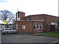
St. Alban's Church, Ashmore Park, Wednesfield
Image: © Geoff Pick
Taken: 26 Jan 2008
0.10 miles
2
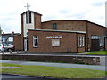
St Alban's C of E Church, Griffiths Drive, Ashmore Park
Image: © Richard Law
Taken: 22 Jul 2011
0.10 miles
3
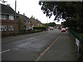
North end of Townson Road, Ashmore Park
Seen from Peacock Avenue.
Image: © Richard Vince
Taken: 22 Sep 2017
0.12 miles
4
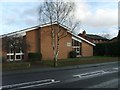
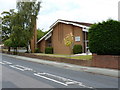
Mormon Church
The Church stands in Linthouse Lane.
Image: © Gordon Griffiths
Taken: 10 Jan 2008
0.12 miles
5
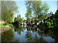
The Wyrley & Essington Canal in use
Dog walkers on the towpath [Monarch's Way] and a boat moored at the end of a back garden. Seen from a narrowboat heading west.
Image: © Christine Johnstone
Taken: 7 May 2018
0.12 miles
6
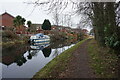
Wyrley & Essington Canal towards Castle Bridge
Image: © Ian S
Taken: 16 Dec 2021
0.13 miles
7
The church of Jesus Christ of the Latter Day Saints, Linthouse Lane
Image: © Richard Law
Taken: 22 Jul 2011
0.14 miles
8

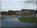
Mini roundabout on Griffiths Drive, Ashmore Park
At this point, near the south western corner of the estate, Griffiths Drive (the main distributor road through the estate) loops back round to meet itself; therefore, all three exits from the mini roundabout are parts of Griffiths Drive.
Image: © Richard Vince
Taken: 22 Sep 2017
0.14 miles
9
Griffiths Drive
The Roundabout as Griffiths Drive meets Linthouse Lane.
Image: © Gordon Griffiths
Taken: 10 Jan 2008
0.14 miles
10

Open space outside shops, Ashmore Park
This is a site of archaeological interest, as the open space contains an ancient moat.
Image: © Richard Vince
Taken: 22 Sep 2017
0.14 miles