IMAGES TAKEN NEAR TO
Clanfield Avenue, WOLVERHAMPTON, WV11 2PJ
Introduction
This page details the photographs taken nearby to Clanfield Avenue, WV11 2PJ by members of the Geograph project.
The Geograph project started in 2005 with the aim of publishing, organising and preserving representative images for every square kilometre of Great Britain, Ireland and the Isle of Man.

There are currently over 7.5m images from over14,400 individuals and you can help contribute to the project by visiting https://www.geograph.org.uk
Image Map
Images are licensed for reuse under creativecommons.org/licenses/by-sa/2.0
Notes
- Clicking on the map will re-center to the selected point.
- The higher the marker number, the further away the image location is from the centre of the postcode.
Image Listing (29 Images Found)
Images are licensed for reuse under creativecommons.org/licenses/by-sa/2.0
Image
Details
Distance
1
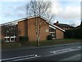
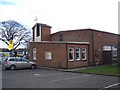
Mormon Church
The Church stands in Linthouse Lane.
Image: © Gordon Griffiths
Taken: 10 Jan 2008
0.08 miles
2
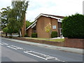
The church of Jesus Christ of the Latter Day Saints, Linthouse Lane
Image: © Richard Law
Taken: 22 Jul 2011
0.09 miles
3
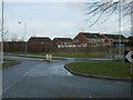
Griffiths Drive
The Roundabout as Griffiths Drive meets Linthouse Lane.
Image: © Gordon Griffiths
Taken: 10 Jan 2008
0.09 miles
4
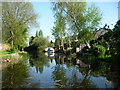
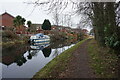
The Wyrley & Essington Canal in use
Dog walkers on the towpath [Monarch's Way] and a boat moored at the end of a back garden. Seen from a narrowboat heading west.
Image: © Christine Johnstone
Taken: 7 May 2018
0.10 miles
5
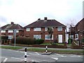
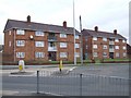
Council Housing - Griffiths Drive
The Ashmore Park Estate was built in the early 1950s to provide overspill housing for Wolverhampton in the neighbouring Wednesfield UDC. Along with the Long Knowle Estate this doubled the population within the UDC within 10 years and developed almost all of the building land. The estate encompasses the former Ashmore Park Colliery and is centred on a medieval moated farm.
The low brick walls are characteristic of this and the Long Knowle estates.
The road is named after A M Griffiths a local builder and councillor.
Image: © John M
Taken: 16 Jan 2011
0.11 miles
6
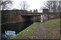
Wyrley & Essington Canal towards Castle Bridge
Image: © Ian S
Taken: 16 Dec 2021
0.11 miles
7
St. Alban's Church, Ashmore Park, Wednesfield
Image: © Geoff Pick
Taken: 26 Jan 2008
0.12 miles
8
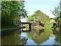
Olinthus Bridge, from the east
Carrying Linthouse Lane over the Wyrley & Essington Canal. Are 'Linthouse' and 'Olinthus'versions of the same word?
Image: © Christine Johnstone
Taken: 7 May 2018
0.12 miles
10
Council Housing - Griffiths Drive
The Ashmore Park Estate was built in the early 1950s to provide overspill housing for Wolverhampton in the neighbouring Wednesfield UDC. Along with the Long Knowle Estate this doubled the population within the UDC within 10 years and developed almost all of the building land. The estate encompasses the former Ashmore Park Colliery and is centred on a medieval moated farm.
Image: © John M
Taken: 16 Jan 2011
0.12 miles