IMAGES TAKEN NEAR TO
Snape Road, WOLVERHAMPTON, WV11 2PA
Introduction
This page details the photographs taken nearby to Snape Road, WV11 2PA by members of the Geograph project.
The Geograph project started in 2005 with the aim of publishing, organising and preserving representative images for every square kilometre of Great Britain, Ireland and the Isle of Man.

There are currently over 7.5m images from over14,400 individuals and you can help contribute to the project by visiting https://www.geograph.org.uk
Image Map
Images are licensed for reuse under creativecommons.org/licenses/by-sa/2.0
Notes
- Clicking on the map will re-center to the selected point.
- The higher the marker number, the further away the image location is from the centre of the postcode.
Image Listing (4 Images Found)
Images are licensed for reuse under creativecommons.org/licenses/by-sa/2.0
Image
Details
Distance
1
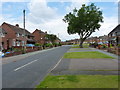
Ashmore Avenue
One of the major roads through the Ashmore Park estate
Image: © Richard Law
Taken: 22 Jul 2011
0.04 miles
2
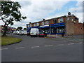
Parade of shops - Higgs Road
A small shopping development within the Ashmore Park estate.
Image: © Richard Law
Taken: 22 Jul 2011
0.14 miles
3
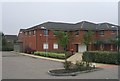
Health Centre on Coppice Farm Estate
Modern health centre serving the Coppice Farm Estate.
Image: © John M
Taken: 16 Sep 2006
0.21 miles
4
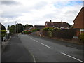
Rogers Close, Ashmore Park
Seen from Griffiths Drive.
Image: © Richard Vince
Taken: 22 Sep 2017
0.24 miles