IMAGES TAKEN NEAR TO
Ashmore Avenue, WOLVERHAMPTON, WV11 2LT
Introduction
This page details the photographs taken nearby to Ashmore Avenue, WV11 2LT by members of the Geograph project.
The Geograph project started in 2005 with the aim of publishing, organising and preserving representative images for every square kilometre of Great Britain, Ireland and the Isle of Man.

There are currently over 7.5m images from over14,400 individuals and you can help contribute to the project by visiting https://www.geograph.org.uk
Image Map
Images are licensed for reuse under creativecommons.org/licenses/by-sa/2.0
Notes
- Clicking on the map will re-center to the selected point.
- The higher the marker number, the further away the image location is from the centre of the postcode.
Image Listing (14 Images Found)
Images are licensed for reuse under creativecommons.org/licenses/by-sa/2.0
Image
Details
Distance
1
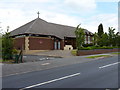
The Corpus Christi Catholic Church, Ashmore Park
Located at the southern end of Ashmore Avenue, at the junction with Griffiths Drive
Image: © Richard Law
Taken: 22 Jul 2011
0.10 miles
4
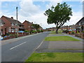
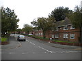
Ashmore Avenue
One of the major roads through the Ashmore Park estate
Image: © Richard Law
Taken: 22 Jul 2011
0.16 miles
5
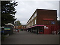
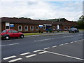
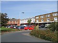
Shopping precinct, Ashmore Park
Ashmore Park's main shopping centre, towards the south western corner of the estate. The chippy on the right serves the wonderful Black Country delicacy that is orange chips.
Image: © Richard Vince
Taken: 22 Sep 2017
0.19 miles
6
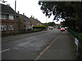
West end of Newey Road, Ashmore Park
Seen from Peacock Avenue.
Image: © Richard Vince
Taken: 22 Sep 2017
0.20 miles
7
North end of Townson Road, Ashmore Park
Seen from Peacock Avenue.
Image: © Richard Vince
Taken: 22 Sep 2017
0.22 miles
8
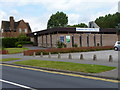
Baptist Church, Griffiths Drive, Ashmore Park
Image: © Richard Law
Taken: 22 Jul 2011
0.22 miles
9
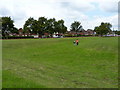
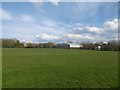
The moat of Ashmore Park Farm
There's very little left of the moat, apart from this slightly depressed area of grass (where the two girls are walking) but it represents the remains of a moated medieval farm settlement, which also had a fishpond just outside the moat. A later (19th Century) farm building just to the south was demolished in the 1950s, at roughly the time that the Ashmore Park estate was being built.
Image: © Richard Law
Taken: 22 Jul 2011
0.22 miles
10
Local Shopping Centre
Grass area in front of the shopping area has evidence of an old moat.
Image: © John M
Taken: 9 Sep 2006
0.23 miles