IMAGES TAKEN NEAR TO
Phillips Avenue, WOLVERHAMPTON, WV11 2HG
Introduction
This page details the photographs taken nearby to Phillips Avenue, WV11 2HG by members of the Geograph project.
The Geograph project started in 2005 with the aim of publishing, organising and preserving representative images for every square kilometre of Great Britain, Ireland and the Isle of Man.

There are currently over 7.5m images from over14,400 individuals and you can help contribute to the project by visiting https://www.geograph.org.uk
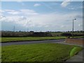
Image Map
Images are licensed for reuse under creativecommons.org/licenses/by-sa/2.0
Notes
- Clicking on the map will re-center to the selected point.
- The higher the marker number, the further away the image location is from the centre of the postcode.
Image Listing (7 Images Found)
Images are licensed for reuse under creativecommons.org/licenses/by-sa/2.0
Image
Details
Distance
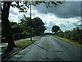
2
Over the edge
Looking out of Ashmore Park to the block of surviving farmland at Prestwood.
Image: © Richard Webb
Taken: 13 Apr 2016
0.19 miles
4
Baylis Avenue, Ashmore Park
A postwar housing expansion of Wednesfield.
Image: © Richard Webb
Taken: 13 Apr 2016
0.20 miles
5
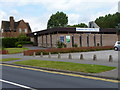
Baptist Church, Griffiths Drive, Ashmore Park
Image: © Richard Law
Taken: 22 Jul 2011
0.23 miles
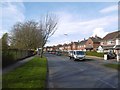
6
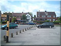
Houses on Griffiths Drive
Houses opposite shops. This view is used as a location for a painting by Wolverhampton born artist David Rayson.
See image 'Somewhere else is here' http://www.artwords.co.uk/acatalog/david_rayson_somewhere_else_is_here.jpg
Image: © Colin Pyle
Taken: Unknown
0.24 miles
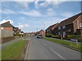
7
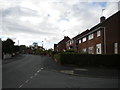
Thornley Road, Ashmore Park
Seen from the end of Millbank Street (right foreground).
Image: © Richard Vince
Taken: 22 Sep 2017
0.25 miles