IMAGES TAKEN NEAR TO
Roach Crescent, WOLVERHAMPTON, WV11 2EW
Introduction
This page details the photographs taken nearby to Roach Crescent, WV11 2EW by members of the Geograph project.
The Geograph project started in 2005 with the aim of publishing, organising and preserving representative images for every square kilometre of Great Britain, Ireland and the Isle of Man.

There are currently over 7.5m images from over14,400 individuals and you can help contribute to the project by visiting https://www.geograph.org.uk
Image Map
Images are licensed for reuse under creativecommons.org/licenses/by-sa/2.0
Notes
- Clicking on the map will re-center to the selected point.
- The higher the marker number, the further away the image location is from the centre of the postcode.
Image Listing (24 Images Found)
Images are licensed for reuse under creativecommons.org/licenses/by-sa/2.0
Image
Details
Distance
1
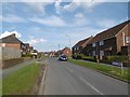
Baylis Avenue, Ashmore Park
A postwar housing expansion of Wednesfield.
Image: © Richard Webb
Taken: 13 Apr 2016
0.06 miles
2
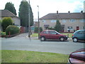
Houses on Blackham Road.
This location is the basis for a painting by artist David Rayson.
Image: © Colin Pyle
Taken: Unknown
0.09 miles
3
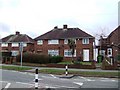
Council Housing - Griffiths Drive
The Ashmore Park Estate was built in the early 1950s to provide overspill housing for Wolverhampton in the neighbouring Wednesfield UDC. Along with the Long Knowle Estate this doubled the population within the UDC within 10 years and developed almost all of the building land. The estate encompasses the former Ashmore Park Colliery and is centred on a medieval moated farm.
The low brick walls are characteristic of this and the Long Knowle estates.
The road is named after A M Griffiths a local builder and councillor.
Image: © John M
Taken: 16 Jan 2011
0.10 miles
4
Council Housing - Griffiths Drive
The Ashmore Park Estate was built in the early 1950s to provide overspill housing for Wolverhampton in the neighbouring Wednesfield UDC. Along with the Long Knowle Estate this doubled the population within the UDC within 10 years and developed almost all of the building land. The estate encompasses the former Ashmore Park Colliery and is centred on a medieval moated farm.
Image: © John M
Taken: 16 Jan 2011
0.11 miles
5

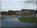
Mini roundabout on Griffiths Drive, Ashmore Park
At this point, near the south western corner of the estate, Griffiths Drive (the main distributor road through the estate) loops back round to meet itself; therefore, all three exits from the mini roundabout are parts of Griffiths Drive.
Image: © Richard Vince
Taken: 22 Sep 2017
0.12 miles
6
Over the edge
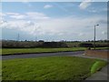
Looking out of Ashmore Park to the block of surviving farmland at Prestwood.
Image: © Richard Webb
Taken: 13 Apr 2016
0.13 miles
7
Griffiths Drive
The Roundabout as Griffiths Drive meets Linthouse Lane.
Image: © Gordon Griffiths
Taken: 10 Jan 2008
0.13 miles
8
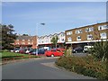
Houses on Griffiths Drive
Houses opposite shops. This view is used as a location for a painting by Wolverhampton born artist David Rayson.
See image 'Somewhere else is here' http://www.artwords.co.uk/acatalog/david_rayson_somewhere_else_is_here.jpg
Image: © Colin Pyle
Taken: Unknown
0.13 miles
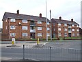
9
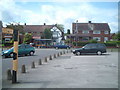
Local Shopping Centre
Grass area in front of the shopping area has evidence of an old moat.
Image: © John M
Taken: 9 Sep 2006
0.14 miles
10

Open space outside shops, Ashmore Park
This is a site of archaeological interest, as the open space contains an ancient moat.
Image: © Richard Vince
Taken: 22 Sep 2017
0.15 miles