IMAGES TAKEN NEAR TO
Sneyd Lane, WOLVERHAMPTON, WV11 2EA
Introduction
This page details the photographs taken nearby to Sneyd Lane, WV11 2EA by members of the Geograph project.
The Geograph project started in 2005 with the aim of publishing, organising and preserving representative images for every square kilometre of Great Britain, Ireland and the Isle of Man.

There are currently over 7.5m images from over14,400 individuals and you can help contribute to the project by visiting https://www.geograph.org.uk
Image Map
Images are licensed for reuse under creativecommons.org/licenses/by-sa/2.0
Notes
- Clicking on the map will re-center to the selected point.
- The higher the marker number, the further away the image location is from the centre of the postcode.
Image Listing (28 Images Found)
Images are licensed for reuse under creativecommons.org/licenses/by-sa/2.0
Image
Details
Distance
1
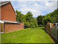
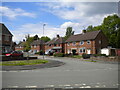
Grassy footpath off Fletcher Road, Allens Rough
Image: © Richard Vince
Taken: 29 May 2021
0.06 miles
2
Colliery railway
In 1906 a railway was constructed between Sneyd Colliery and a new landsale and canal basin at Short Heath on the Wyrley and Essington Canal. This closed in the late 1960s with the demise of Hilton Main colliery and opencast working on the Sneyd Colliery site.
Image: © John M
Taken: 18 Apr 2009
0.06 miles
3
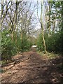
North end of Heath Road, Allens Rough
Looking towards Sneyd Lane from the junction with Fletcher Road.
Image: © Richard Vince
Taken: 29 May 2021
0.07 miles
4
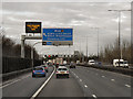
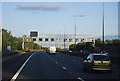
Northbound M6 approaching Junction 10A
The matrix sign ahead is informing drivers that, although the hard shoulder is being used as a running lane, it should only be used by traffic which will be leaving the M6 to join the M54.
This is an example of the Active Traffic Management (ATM) system used on certain motorways where gantry signs are computer-controlled to set a variable speed limit, open the hard shoulder as a running lane and limit the volume of traffic entering at junctions, with the aim of improving the flow of traffic (see http://www.cbrd.co.uk/indepth/atm/ for more detailed information about the Active Traffic Management system).
Image: © David Dixon
Taken: 21 Dec 2012
0.07 miles
5
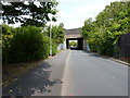
The former colliery railway bridge, from the south
John's description of http://www.geograph.org.uk/photo/1257945 tells us all we need to know about this bridge under the M6.
Image: © Richard Law
Taken: 3 Aug 2011
0.07 miles
6
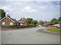
East end of Stretton Road, Allens Rough
Seen from its junction with Heath Road.
Image: © Richard Vince
Taken: 29 May 2021
0.08 miles
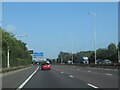
7

Walsall : M6 Motorway
The M6 Motorway between Junction 10 (Walsall Interchange) and Junction 10A.
Image: © Lewis Clarke
Taken: 22 Sep 2019
0.10 miles
8
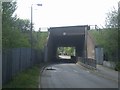
Colliery railway bridge under M6 at the Sneyd
The railway ran from the Sneyd Colliery to a wharf on the Wyrley and Essington Canal at Short Heath. The bridge was built in the late 1960s. The line was taken out of use shortly after this. The bridge provides an access to Sneyd Community School built in 1980 on a former open-cast site and a watersports centre.
Image: © John M
Taken: 18 Apr 2009
0.12 miles
9
Approaching junction for M54 on the M6 Motorway northbound
Image: © Roy Hughes
Taken: 26 Aug 2024
0.12 miles