IMAGES TAKEN NEAR TO
Red Lane, WOLVERHAMPTON, WV11 2DY
Introduction
This page details the photographs taken nearby to Red Lane, WV11 2DY by members of the Geograph project.
The Geograph project started in 2005 with the aim of publishing, organising and preserving representative images for every square kilometre of Great Britain, Ireland and the Isle of Man.

There are currently over 7.5m images from over14,400 individuals and you can help contribute to the project by visiting https://www.geograph.org.uk
Image Map
Images are licensed for reuse under creativecommons.org/licenses/by-sa/2.0
Notes
- Clicking on the map will re-center to the selected point.
- The higher the marker number, the further away the image location is from the centre of the postcode.
Image Listing (14 Images Found)
Images are licensed for reuse under creativecommons.org/licenses/by-sa/2.0
Image
Details
Distance
1
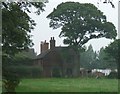
Farbrook Farm near Essington
This farm lies between M6 motorway and housing on Sneyd Lane.
Image: © John M
Taken: 16 Sep 2006
0.04 miles
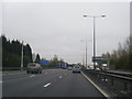
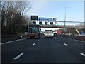
2
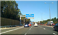
M6 North nears junction 10a
Works continue along the M6 with new signs, gantries, cameras, noise and crash barriers. Ahead, a bridge carries a public footpath between Bloxwich and Essington.
Image: © Robin Stott
Taken: 25 Sep 2010
0.13 miles
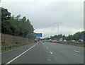
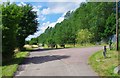
4
South Staffordshire : The M6 Motorway
Heading along the M6 Motorway as it heads north through South Staffordshire.
Image: © Lewis Clarke
Taken: 21 Apr 2016
0.18 miles
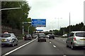
5
Essington : M6 Motorway
The M6 Motorway between Junction 10 (Walsall Interchange) and Junction 10A.
Image: © Lewis Clarke
Taken: 22 Sep 2019
0.18 miles
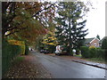
8
Red Lane, Essington, Staffs
Red Lane is a very long mainly single track farm road, giving access to various properties. At one end it has a junction with Bursnips Road (part of the A462), and at the other end it has a junction with Sneyd Lane. In this view there can be seen the start of the spur, on the right, which goes over the M6 motorway to give vehicular access to Sneyd Farm, the C.A.A.R.S. animal sanctuary and All Seasons Boarding Kennels & Cattery. Red Lane, in this direction, and the spur, carry a public footpath over them.
Image
Image: © P L Chadwick
Taken: 3 Aug 2013
0.19 miles
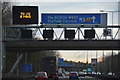
10
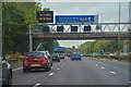
Motorway direction signs over the M6
The sign is for the M54 to Shrewsbury.
Image: © Steve Daniels
Taken: 17 Jun 2015
0.20 miles