IMAGES TAKEN NEAR TO
Wolverhampton Road, WOLVERHAMPTON, WV11 2DB
Introduction
This page details the photographs taken nearby to Wolverhampton Road, WV11 2DB by members of the Geograph project.
The Geograph project started in 2005 with the aim of publishing, organising and preserving representative images for every square kilometre of Great Britain, Ireland and the Isle of Man.

There are currently over 7.5m images from over14,400 individuals and you can help contribute to the project by visiting https://www.geograph.org.uk
Image Map
Images are licensed for reuse under creativecommons.org/licenses/by-sa/2.0
Notes
- Clicking on the map will re-center to the selected point.
- The higher the marker number, the further away the image location is from the centre of the postcode.
Image Listing (19 Images Found)
Images are licensed for reuse under creativecommons.org/licenses/by-sa/2.0
Image
Details
Distance
1
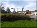
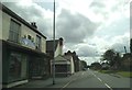
Signpost, Essington
Brown shore Lane/Wolverhampton road junction with a finger post.
Image: © Richard Webb
Taken: 13 Apr 2016
0.03 miles
4
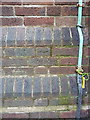
OS benchmark - Essington, St John's church
An OS cutmark at the base of the tower of Image; originally levelled at 183.429m above Ordnance Datum Newlyn.
Image: © Richard Law
Taken: 6 Oct 2014
0.10 miles
5
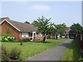
Sheltered Housing
Off the main street in Essington village centre.
Image: © John M
Taken: 10 Jun 2007
0.11 miles
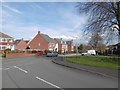
6
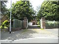
Church Gates
The view from Wolverhampton Road towards St. John's Church in Essington.
Image: © Gordon Griffiths
Taken: 27 Jun 2016
0.11 miles
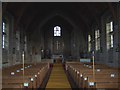
7
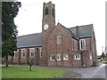
St John's Church
Mid-day Christmas Day 2012. After the briefest glimpse of the sun this morning it has started spotting with rain in the West Midlands.
Image: © John M
Taken: 25 Dec 2012
0.11 miles
8
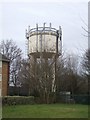
Redundant water tower
The tower was last used for water supply a decade ago but since 2003 has been home to various mobile phone masts. There are calls for the water tower to be demolished due to concerns for the health of local residents. It is thought that as the tower is no longer used for water supply the right to the land will revert to the local council or its successors allowing the tower to be removed. Essington is situated on the highest ground in the area with views over to the Black Country, Wolverhampton and Dudley. It is a prime location for mobile phone and telecommunications masts and is near the junction of the M6, M6 Toll and M54 Motorways. A local campaign group, FAME, (Fight Against Masts in Essington) campaigns against any new mast proposals.
Image: © John M
Taken: 27 Jan 2010
0.14 miles
9
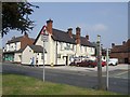
Minerva Scene
The view alongside the Minerva Public House in the former mining village of Essington.
Image: © Gordon Griffiths
Taken: 27 Jun 2016
0.15 miles
10
The Minerva
Public House in the former mining village of Essington.
Image: © John M
Taken: 10 Jun 2007
0.16 miles