IMAGES TAKEN NEAR TO
Blackhalve Lane, WOLVERHAMPTON, WV11 2BB
Introduction
This page details the photographs taken nearby to Blackhalve Lane, WV11 2BB by members of the Geograph project.
The Geograph project started in 2005 with the aim of publishing, organising and preserving representative images for every square kilometre of Great Britain, Ireland and the Isle of Man.

There are currently over 7.5m images from over14,400 individuals and you can help contribute to the project by visiting https://www.geograph.org.uk
Image Map
Images are licensed for reuse under creativecommons.org/licenses/by-sa/2.0
Notes
- Clicking on the map will re-center to the selected point.
- The higher the marker number, the further away the image location is from the centre of the postcode.
Image Listing (22 Images Found)
Images are licensed for reuse under creativecommons.org/licenses/by-sa/2.0
Image
Details
Distance
1
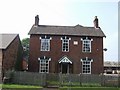
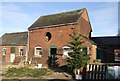
Oakley Farm
Family run dairy farm. The farmhouse was built in 1881.
Image: © John M
Taken: 10 Jun 2007
0.07 miles
2
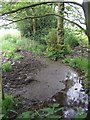
Waterhead Brook downstream of the mineral railway
Passing under the embankment of the disused railway the brook flows past Oakley Farm.
Image: © John M
Taken: 12 Jun 2010
0.08 miles
3
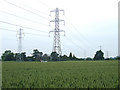
Pylons across the Wheat Field, near Wood Hayes, Staffordshire
The pylons on the left have recently been replaced. The cables are carried on rollers until the isolators have been fitted. The electricians are working their way up the line and are about four pylons away. The scaffolding at the edge of the field was used to keep the cables above the traffic on Blackhalve Lane.
Image: © Roger Kidd
Taken: 7 Jun 2007
0.09 miles
4
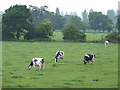
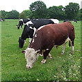
Grazing Dairy Cattle, near Wood Hayes, Staffordshire
Image: © Roger Kidd
Taken: 7 Jun 2007
0.09 miles
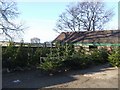
5
Barn at Oakley Farm
Christmas trees are sold in the farmyard as well as the usual eggs, potatoes and animal feed.
Image: © John M
Taken: 19 Dec 2009
0.09 miles
6
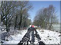
Dog walkers on the old railway
This section of the old Hilton Main Colliery line is used as a footpath between here and Westcroft.
Image: © John M
Taken: 6 Apr 2008
0.10 miles
7
The Gaffer, and Friends
Handsome, or what? There is a very small gap in the hedge (which is too high to see over) after ploughing across a couple of metres of nettles. I just expected another view of the cows..... so what a wonderful surprise. He took one derisive look at me, and carried on munching!
Image: © Roger Kidd
Taken: 7 Jun 2007
0.11 miles
8
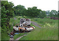
Something Nasty on the Track
The "authorities" have placed substantial barriers at GR SO948025 now, where the former railway track crosses the lane, but did not consider it worth while removing this eyesore first. I don't think it could have been driven in from the north. The track now is a rather pleasant public footpath which leads towards Westcroft.
Image: © Roger Kidd
Taken: 7 Jun 2007
0.11 miles
9
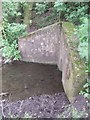
Waterhead Brook Culvert
A small culvert allows the brook to pass beneath the former mineral railway embankment from Hilton Main Colliery. The shafts of the colliery were sunk in 1919 and production ceased in 1969.
Image: © John M
Taken: 12 Jun 2010
0.11 miles
10
Christmas trees for sale at Oakley Farm
Six days before Christmas. There are plenty of trees available this year at the farm.
Image: © John M
Taken: 19 Dec 2009
0.12 miles