IMAGES TAKEN NEAR TO
Warstone Road, WOLVERHAMPTON, WV11 2AR
Introduction
This page details the photographs taken nearby to Warstone Road, WV11 2AR by members of the Geograph project.
The Geograph project started in 2005 with the aim of publishing, organising and preserving representative images for every square kilometre of Great Britain, Ireland and the Isle of Man.

There are currently over 7.5m images from over14,400 individuals and you can help contribute to the project by visiting https://www.geograph.org.uk
Image Map
Images are licensed for reuse under creativecommons.org/licenses/by-sa/2.0
Notes
- Clicking on the map will re-center to the selected point.
- The higher the marker number, the further away the image location is from the centre of the postcode.
Image Listing (6 Images Found)
Images are licensed for reuse under creativecommons.org/licenses/by-sa/2.0
Image
Details
Distance
1
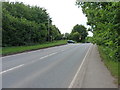
Hilton Lane emerges onto Warstone Road
Hilton Lane makes for a convenient, and well-used, shortcut between Warstone and the Shareshill/Featherstone area, neatly avoiding any traffic buildup around J11 of the M6.
Image: © Richard Law
Taken: 14 Jun 2017
0.08 miles
3
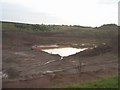
Wet quarry
This old clay pit is next to Warstone Road.
Image: © John M
Taken: 12 Nov 2006
0.15 miles
4
Quarry on Warstone Road
Clay pit and open cast quarrying off Warstone Road near Essington.
Image: © John M
Taken: 12 Nov 2006
0.16 miles
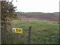
5
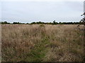
Footpath through a reclaimed meadow
Much of this land has previously been quarried for clay & coal, and this rough meadow certainly has the feel of restored land about it.
Image: © Richard Law
Taken: 16 Oct 2014
0.23 miles
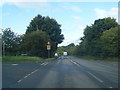
6

Old Warstone Lane to junction with Hilton Lane
Image: © Mick Malpass
Taken: 10 Sep 2011
0.23 miles