IMAGES TAKEN NEAR TO
Okement Drive, WOLVERHAMPTON, WV11 1XD
Introduction
This page details the photographs taken nearby to Okement Drive, WV11 1XD by members of the Geograph project.
The Geograph project started in 2005 with the aim of publishing, organising and preserving representative images for every square kilometre of Great Britain, Ireland and the Isle of Man.

There are currently over 7.5m images from over14,400 individuals and you can help contribute to the project by visiting https://www.geograph.org.uk
Image Map
Images are licensed for reuse under creativecommons.org/licenses/by-sa/2.0
Notes
- Clicking on the map will re-center to the selected point.
- The higher the marker number, the further away the image location is from the centre of the postcode.
Image Listing (167 Images Found)
Images are licensed for reuse under creativecommons.org/licenses/by-sa/2.0
Image
Details
Distance
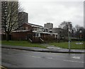
1
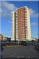
Tower Block in Wednesfield
Refurbished 1960s tower block built for Wednesfield UDC.
Image: © John M
Taken: 19 Jan 2014
0.01 miles
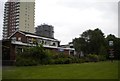
2
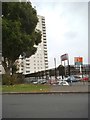
Wednesfield Flats View
The view from Graiseley Lane, Wednesfield.
Image: © Gordon Griffiths
Taken: 10 Oct 2015
0.03 miles
3
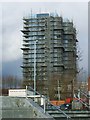
Tower Block in Wednesfield
The 1960s block originally built for Wednesfield UDC is currently undergoing a facelift under the 'Decent Homes' programme.
Image: © John M
Taken: 24 Dec 2013
0.06 miles
4
The Village Inn
On the edge of Wednesfield and next to New Cross Hospital. It does look possibly closed.
Image: © Chris Allen
Taken: 29 Mar 2019
0.06 miles
5
Wednesfield, The Village Inn
Two-roomed pub at the corner of Wolverhampton Road and Graiseley Lane. TV, darts, pool; no cask ale available. For some customer comments, see http://www.beerintheevening.com/pubs/s/38/38473/Village_Inn/Wednesfield
Image: © Mike Faherty
Taken: 16 Jan 2011
0.06 miles
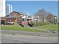
6
The Village Inn, Wednesfield
Overshadowed by the (apparently contemporary) tower blocks, the Village Inn faces Wolverhampton Road (out of frame to the right) as it nears Wednesfield town centre.
Image: © Richard Vince
Taken: 5 Jun 2013
0.06 miles
7
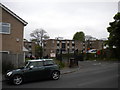
New Heath Close, Wednesfield
This cul de sac, off Graiseley Lane (foreground), leads to several blocks of low rise flats adjacent to the south eastern corner of the New Cross Hospital campus.
Image: © Richard Vince
Taken: 5 Jun 2013
0.07 miles
8
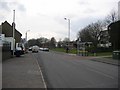
Wolverhampton Road, Wednesfield
Once familiar view from the bus stop. Just west of the canal bridge. The road is quieter now a bypass has been built through old industrial land to the south.
Image: © Richard Webb
Taken: 4 Mar 2004
0.07 miles
9
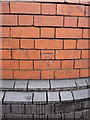
OS benchmark - New Cross, corner of Graisley Lane
An OS cutmark on the wall just a few yards to the left of the Graisley Lane junction; originally levelled at 146.987m above Ordnance Datum Newlyn.
Image: © Richard Law
Taken: 5 Feb 2015
0.07 miles
10
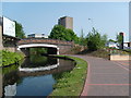
Rookery Bridge
The bridge carries Rookery Street over the Wyrley and Essington Canal.
Image: © Gordon Griffiths
Taken: 28 Apr 2007
0.08 miles