IMAGES TAKEN NEAR TO
Lichfield Road, WOLVERHAMPTON, WV11 1TP
Introduction
This page details the photographs taken nearby to Lichfield Road, WV11 1TP by members of the Geograph project.
The Geograph project started in 2005 with the aim of publishing, organising and preserving representative images for every square kilometre of Great Britain, Ireland and the Isle of Man.

There are currently over 7.5m images from over14,400 individuals and you can help contribute to the project by visiting https://www.geograph.org.uk
Image Map
Images are licensed for reuse under creativecommons.org/licenses/by-sa/2.0
Notes
- Clicking on the map will re-center to the selected point.
- The higher the marker number, the further away the image location is from the centre of the postcode.
Image Listing (77 Images Found)
Images are licensed for reuse under creativecommons.org/licenses/by-sa/2.0
Image
Details
Distance
1
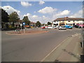
Lichfield Road Island
The view in Wednesfield, Wolverhampton.
Image: © Gordon Griffiths
Taken: 8 Aug 2015
0.03 miles
2
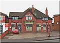
The Cross Guns, 43 Lichfield Road, Wednesfield
This public house has closed and I have no information as to the future use of the building. The post outside, which used to hold the pub's sign, has had its top removed, which is probably not a good sign for any possible re-opening plan. The windows at the front have also been changed.
Image: © P L Chadwick
Taken: 29 Dec 2011
0.05 miles
3
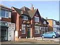
Cross Guns - Lichfield Road
Post-war public house.
Image: © John M
Taken: 15 Nov 2009
0.05 miles
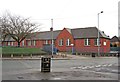
4
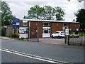
Seventh-Day Adventist Church
A polling station for the EU Referendum.
Image: © John M
Taken: 23 Jun 2016
0.06 miles
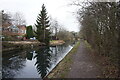
5
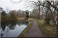
Wyrley & Essington Canal towards Wards Bridge
Image: © Ian S
Taken: 16 Dec 2021
0.06 miles
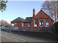
6
Edward the Elder Nursery School, Lichfield Road, Wednesfield
Named after King Edward the Elder who was the son of King Alfred the Great. He ruled the Kingdom of Wessex and later Mercia also, in the early 10th century. He is chiefly remembered today for a decisive battle when the Danes were defeated. It is believed to have been fought somewhere in the vicinity of Wednesfield.
Image: © P L Chadwick
Taken: 29 Dec 2011
0.07 miles
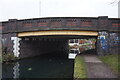
8

Wyley Canal
The view down the Wyrley & Essington Canal in Wednesfield from the Lichfield Road bridge.
Image: © Gordon Griffiths
Taken: 8 Aug 2015
0.08 miles
9
King Edward the Elder Nursery
The former Wednesfield Village Primary School merged with Moathouse School on the Moathouse site in 2007 due to falling rolls. A nursery school operates on the site in the 1910 building.
King Edward the Elder was a king of Mercia who led his army to a decisive victory over the Danes at the Battle of Wodensfelde.
Image: © John M
Taken: 15 Nov 2009
0.08 miles
10
Wyrley & Essington Canal towards Wards Bridge
Image: © Ian S
Taken: 16 Dec 2021
0.08 miles