
IMAGES TAKEN NEAR TO
Church Street, WOLVERHAMPTON, WV11 1SR
Introduction
This page details the photographs taken nearby to Church Street, WV11 1SR by members of the Geograph project.
The Geograph project started in 2005 with the aim of publishing, organising and preserving representative images for every square kilometre of Great Britain, Ireland and the Isle of Man.

There are currently over 7.5m images from over14,400 individuals and you can help contribute to the project by visiting https://www.geograph.org.uk
Image Map
Images are licensed for reuse under creativecommons.org/licenses/by-sa/2.0
Notes
- Clicking on the map will re-center to the selected point.
- The higher the marker number, the further away the image location is from the centre of the postcode.
Image Listing (170 Images Found)
Images are licensed for reuse under creativecommons.org/licenses/by-sa/2.0
Image
Details
Distance
1
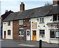
Nos 1, 3 & 5 Church Street, Wednesfield
Formerly houses, but now 3 shop units, which date from the early/mid 18th century, and although they appear to be brick-built, there's actually a substantial amount of timber framing to the internal structures. They were collectively Grade II listed https://britishlistedbuildings.co.uk/101201799-13-and-5-church-street-wednesfield-south-ward#.W3Xi1tQrLGg in 1992.
Image: © Richard Law
Taken: 19 Jul 2018
0.01 miles
2

High Street View
The view up Wednesfield High Street.
Image: © Gordon Griffiths
Taken: 5 Mar 2019
0.01 miles
3
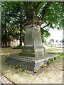
The Bate family monument in Wednesfield churchyard
The sandstone ashlar monument records the lives, or more accurately the deaths, of three members of the Bate family - Ann who died in 1842, Jane who died in 1868, and John who died in 1876. It was once surrounded by iron railings, but these have been cut off near ground level (possibly as part of the 'War Effort' in the 1940s) and was Grade II listed https://britishlistedbuildings.co.uk/101205516-bate-monument-approximately-20-metres-south-of-church-of-st-thomas-wednesfield-south-ward#.W3XhMtQrLGg in 1992.
Image: © Richard Law
Taken: 19 Jul 2018
0.02 miles
4
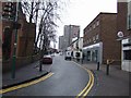
Banking off the High Street, Xmas Day 2007
A bank customer uses a 'Hole in the Wall' cash dispenser on Christmas Day.
Image: © John M
Taken: 25 Dec 2007
0.02 miles
5
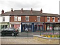
Shops, High Street
Surviving 19th century buildings on the High Street, Wednesfield. There were others over the road, cleared many years before the library was built.
Image: © Richard Webb
Taken: 1 May 2010
0.02 miles
6
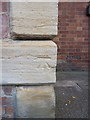
OS benchmark - Wednesfield, St Thomas's church
An OS cutmark on the west face of the church, originally levelled at 144.417m above Ordnance Datum Newlyn, probably in 1957.
Image: © Richard Law
Taken: 19 Jul 2018
0.03 miles
7

Wednesfield Library and Church
St Thomas's Church and typical late 1950s library taken from the Garden of Remembrance.
Image: © John M
Taken: 3 Sep 2006
0.03 miles
8
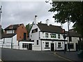
Boat Public House, Wednesfield
A traditional public house from around 1800 in a conservation area adjacent to St Thomas's church in Wednesfield village centre. The brewhouse is a rare survival. See http://www.localhistory.scit.wlv.ac.uk/listed/wedboatph.htm
A correspondent commented that he was living at the Boat as a young boy. The adjacent building was living accommodation downstairs, with an outside flight of wooden stairs. The previous tenants were family and have no recollection of home brewed beer. The cellar was very low and original. He was resident 1952-1957. The Licensee was F.B.Ward
Image: © John M
Taken: 3 Sep 2006
0.03 miles
9
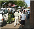
Market day
The market is now held in the High Street in Wednesfield.
Image: © John M
Taken: 15 Sep 2006
0.03 miles
10
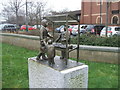
Market trading in Wednesfield
A short while ago a number of small figures appeared at various spots around the village. They are raised up off the ground on small stone plinths. It is a mystery as to who placed them here as there is no plaque or sign attached. These are in front of the Gurdwara.
Image: © John M
Taken: 13 Feb 2016
0.03 miles