IMAGES TAKEN NEAR TO
Victoria Road, WOLVERHAMPTON, WV11 1RY
Introduction
This page details the photographs taken nearby to Victoria Road, WV11 1RY by members of the Geograph project.
The Geograph project started in 2005 with the aim of publishing, organising and preserving representative images for every square kilometre of Great Britain, Ireland and the Isle of Man.

There are currently over 7.5m images from over14,400 individuals and you can help contribute to the project by visiting https://www.geograph.org.uk
Image Map
Images are licensed for reuse under creativecommons.org/licenses/by-sa/2.0
Notes
- Clicking on the map will re-center to the selected point.
- The higher the marker number, the further away the image location is from the centre of the postcode.
Image Listing (31 Images Found)
Images are licensed for reuse under creativecommons.org/licenses/by-sa/2.0
Image
Details
Distance
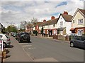
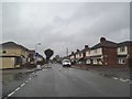
2
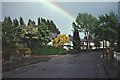
Vicarage Road, Wednesfield
One of three Vicarage Roads in Wolverhampton Borough. After an early Summer shower.
Image: © Richard Webb
Taken: Unknown
0.04 miles
3
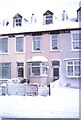
Autumn in Vicarage Road, Wednesfield
This is a quiet residential road with the obligatory traffic humps. Nothing much appears to have altered since January 1991 ImageI don't think we have had quite as much snow since then.
Image: © John M
Taken: 15 Oct 2006
0.04 miles
4
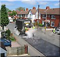
Resurfacing Vicarage Road
Vicarage Road, Wednesfield getting a new coat of bitumen and chippings.
Image: © Richard Webb
Taken: 18 May 2004
0.05 miles
5
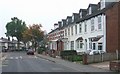
Vicarage Road in Spring
The northern half of the street is a mix of sometimes damp terraced houses (built 1895) and former council stock. Houses with a roof over their door would have been municipal stock around 1990 when the council houses were refurbished. Right to buy houses would have missed this.
Image: © Richard Webb
Taken: 1 May 2010
0.05 miles
6
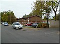
Wednesfield, resource centre
Woden Community Resource Centre, on Vicarage Road; offering daycare, respite and rehabilitation services. http://www.wolverhampton.gov.uk/health_social_care_2/adult_social_care/older_people/care_home/resource_centres/woden.htm
Image: © Mike Faherty
Taken: 13 Oct 2011
0.06 miles
7
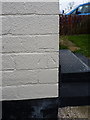
OS benchmark - New Cross, 140 Victoria Road
An OS cutmark on the side wall of no 140 Victoria Road; originally levelled at 157.612m above Ordnance Datum Newlyn.
Image: © Richard Law
Taken: 5 Feb 2015
0.07 miles
8
Pillar box, Vicarage Road (Wednesfield)
Outside what was once a corner shop. The shop was famous for hardly ever having any stock, we were constantly reminded of it when on holiday in Romania just after the coup in 1989.
Image: © Richard Webb
Taken: 1 May 2010
0.07 miles
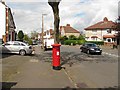
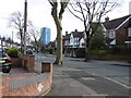
9
Victoria Road Junction
The view of the junction with Packhorse Avenue in Wednesfield.
Image: © Gordon Griffiths
Taken: 19 Aug 2016
0.07 miles
10
Vicarage Road, Wednesfield
Tree lined residential street, although infamously one of the trees did once end up in somebody's house. The flats are now blue.
Image: © Richard Webb
Taken: 13 Apr 2016
0.09 miles