IMAGES TAKEN NEAR TO
Graiseley Lane, WOLVERHAMPTON, WV11 1QN
Introduction
This page details the photographs taken nearby to Graiseley Lane, WV11 1QN by members of the Geograph project.
The Geograph project started in 2005 with the aim of publishing, organising and preserving representative images for every square kilometre of Great Britain, Ireland and the Isle of Man.

There are currently over 7.5m images from over14,400 individuals and you can help contribute to the project by visiting https://www.geograph.org.uk
Image Map
Images are licensed for reuse under creativecommons.org/licenses/by-sa/2.0
Notes
- Clicking on the map will re-center to the selected point.
- The higher the marker number, the further away the image location is from the centre of the postcode.
Image Listing (173 Images Found)
Images are licensed for reuse under creativecommons.org/licenses/by-sa/2.0
Image
Details
Distance
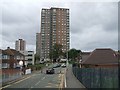
1
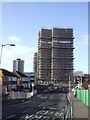
Tower block refurbishment
The nearer pair of 1960s towerblocks are the latest to get a facelift.
Image: © John M
Taken: 27 Jan 2012
0.01 miles
2
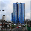
Wednesfield Tower Blocks
The 1960s tower blocks were refurbished under the 'Decent Homes' scheme in 2013.
Image: © John M
Taken: 25 Dec 2017
0.01 miles
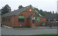
3
Demolition of 'The Institute'
Originally opened 1904 as a Church Institute this building has had many uses. A room was used as the Registrar's Office for births and deaths until Wednesfield Urban District Council was incorporated into Wolverhampton. In the early 1970s it was used as a nursery and dining room for the adjacent Catholic school until their facilities were built. Its latest use was as a snooker club but now to be demolished.
Image: © John M
Taken: 20 Aug 2015
0.04 miles
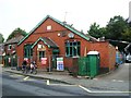
4
Former Church Institute on Graiseley Lane
Originally opened 1904 as a Church Institute this building has had many uses. A room was used as the Registrar's Office for births and deaths until Wednesfield Urban District Council was incorporated into Wolverhampton. In the early 1970s it was used as a nursery and dining room for the adjacent Catholic school until their facilities were built. Its latest use is as a snooker club.
Image: © John M
Taken: 15 Oct 2006
0.04 miles
5
Tower Blocks, Wednesfield
1960s tower blocks near Wednesfield village centre.
Image: © John M
Taken: 3 Sep 2006
0.04 miles
6
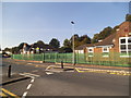
St Patricks School
The view of the Catholic Primary School on Graiseley Lane Wednesfield.
Image: © Gordon Griffiths
Taken: 4 Oct 2015
0.06 miles
8
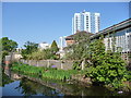
Housing on the north bank of the Wyrley & Essington Canal
Off Graiseley Lane and Torridge Drive, Wednesfield.
Image: © Christine Johnstone
Taken: 7 May 2018
0.07 miles
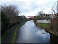
9
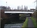
Wyrley & Essington Canal - Church Bridge Footbridge
Image: © John M
Taken: 26 Dec 2006
0.07 miles
10
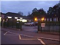
Polling Station - Wolverhampton North East
The nursery at St Patricks RC Primary School hosts a polling station for the 2010 General Election. The surrounding area has pre-war housing, three large blocks of flats and low rise Council housing. The demographic is working class, socially deprived with high unemployment.
Image: © John M
Taken: 6 May 2010
0.07 miles