IMAGES TAKEN NEAR TO
Nordley Road, WOLVERHAMPTON, WV11 1PX
Introduction
This page details the photographs taken nearby to Nordley Road, WV11 1PX by members of the Geograph project.
The Geograph project started in 2005 with the aim of publishing, organising and preserving representative images for every square kilometre of Great Britain, Ireland and the Isle of Man.

There are currently over 7.5m images from over14,400 individuals and you can help contribute to the project by visiting https://www.geograph.org.uk
Image Map
Images are licensed for reuse under creativecommons.org/licenses/by-sa/2.0
Notes
- Clicking on the map will re-center to the selected point.
- The higher the marker number, the further away the image location is from the centre of the postcode.
Image Listing (110 Images Found)
Images are licensed for reuse under creativecommons.org/licenses/by-sa/2.0
Image
Details
Distance
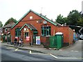
1
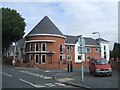
Bentley Court Nursing Home
The new home on the corner of Woden Avenue and Nordley Road will cater for dementia patients.
It is built on the site of the New Crown public house
Image: © John M
Taken: 31 Aug 2009
0.04 miles
2
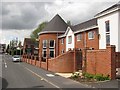
Bentley Court
New care home on the site of the not lamented New Crown pub. (possibly the worst pub I have ever visited).
Image: © Richard Webb
Taken: 1 May 2010
0.05 miles
3
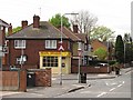
Nordley Road and Woden Avenue
Crossroads in Wednesfield with a carry out and corner shop (most corner shops seem to have disappeared around here). There was a pub opposite, but it has been replaced by a care home, not a sad loss in this case.
Image: © Richard Webb
Taken: 1 May 2010
0.06 miles
4
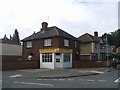
Pearl Dragon Takeaway
Chinese takeaway on the corner of Nordley Road and Frederick Road. The 'New Crown' on the opposing corner was demolished in 2008 and has been replaced by a nursing home.
Image: © John M
Taken: 31 Aug 2009
0.08 miles
5
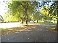
Park Path
The view next to the Wyrley And Essington Canal in Wednesfield Park, Wolverhampton.
Image: © Gordon Griffiths
Taken: 4 Oct 2015
0.12 miles
6
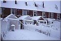
Back of a terrace, Vicarage Road, Wednesfield
Image: © Richard Webb
Taken: Unknown
0.14 miles
7
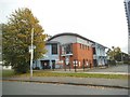
Children's Village
The view from Graiseley Lane, Wednesfield.
Image: © Gordon Griffiths
Taken: 10 Oct 2015
0.14 miles
8
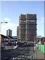
Tower block refurbishment
The nearer pair of 1960s towerblocks are the latest to get a facelift.
Image: © John M
Taken: 27 Jan 2012
0.15 miles
9
Demolition of 'The Institute'
Originally opened 1904 as a Church Institute this building has had many uses. A room was used as the Registrar's Office for births and deaths until Wednesfield Urban District Council was incorporated into Wolverhampton. In the early 1970s it was used as a nursery and dining room for the adjacent Catholic school until their facilities were built. Its latest use was as a snooker club but now to be demolished.
Image: © John M
Taken: 20 Aug 2015
0.15 miles
10
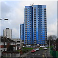
Wednesfield Tower Blocks
The 1960s tower blocks were refurbished under the 'Decent Homes' scheme in 2013.
Image: © John M
Taken: 25 Dec 2017
0.15 miles