IMAGES TAKEN NEAR TO
Gough Avenue, WOLVERHAMPTON, WV11 1EX
Introduction
This page details the photographs taken nearby to Gough Avenue, WV11 1EX by members of the Geograph project.
The Geograph project started in 2005 with the aim of publishing, organising and preserving representative images for every square kilometre of Great Britain, Ireland and the Isle of Man.

There are currently over 7.5m images from over14,400 individuals and you can help contribute to the project by visiting https://www.geograph.org.uk
Image Map
Images are licensed for reuse under creativecommons.org/licenses/by-sa/2.0
Notes
- Clicking on the map will re-center to the selected point.
- The higher the marker number, the further away the image location is from the centre of the postcode.
Image Listing (30 Images Found)
Images are licensed for reuse under creativecommons.org/licenses/by-sa/2.0
Image
Details
Distance
1
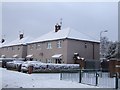
Council Housing - Bradburn Road
These houses on the early 1950s Long Knowle Estate have recently been renovated. Most are obviously still in Council ownership.
Image: © John M
Taken: 19 Dec 2010
0.04 miles
2
Council Housing - Long Knowle Estate
Early 1950s council housing in Guest Avenue. Original flat roof replaced by pitched roof in 1990s.
Image: © John M
Taken: 3 Sep 2006
0.07 miles
3
Polling Station - Wolverhampton North East
The church hall of St Gregory the Great serves as a Polling Station for the 2010 General Election. The polling station caters for a mix of post war private developments and a few older properties. The demographic is older owner occupiers.
Image: © John M
Taken: 6 May 2010
0.08 miles
4
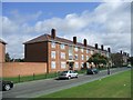
Long Knowle Estate - Guest Avenue
In the immediate post-war period Wolverhampton County Borough required additional housing for a growing population and slum clearance around the town centre. As most building land had been used within the Borough the Council negotiated for several greenfield sites in neighbouring Wednesfield Urban District Council including Long Knowle and Ashmore Park in 1949. By 1953 plans had been finalised and the site work on the traditionally constructed homes started in October 1953. The first home was finished in May 1954 and by August over 100 were complete.
The playing field at the centre of the estate is bounded on one side by the school and on the other three by blocks of three storey flats. The first of these was opened in July 1955. The flats are similar to Princess Court and Queen's Court in Falling's Park built in 1950. Image]
The flats were as much as traditional techniques could achieve for medium density housing and were superseded by the high rise tower blocks of the early 1960s estates.
Image: © John M
Taken: 16 Jan 2018
0.09 miles
5
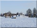
Sledging on the Long Knowle Mound
The steepest slope available on the estate is well used. The mound Image is a new addition to the play area.
Image: © John M
Taken: 9 Jan 2010
0.09 miles
6
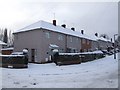
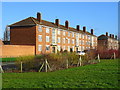
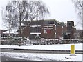
Council Housing - Bradburn Road
These houses on the early 1950s Long Knowle Estate have recently been renovated. A privately owned house shows the original brickwork finish. A feature of the low rise housing is the dwarf brick perimeter walls with brick on edge coping.
Image: © John M
Taken: 19 Dec 2010
0.09 miles
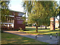
8
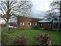
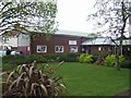
Church hall at St Gregory the Great
Polling station for the local elections in the former church on Blackhalve Lane.
Image: © John M
Taken: 1 May 2008
0.10 miles
9
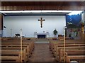
St Gregory the Great Parish Church
The original church hall on the left was built to serve the new council estates built at Long Knowle in the early 1950s. The new church building dates from the mid 1960s.
Image: © John M
Taken: 20 Jan 2013
0.11 miles
10
Church of St Gregory the Great, Wednesfield
A modern church at the corner of Blackhalve Lane and Long Knowle Lane.
Image: © Derek Harper
Taken: 18 Jul 2006
0.11 miles