IMAGES TAKEN NEAR TO
Poplar Avenue, WOLVERHAMPTON, WV11 1DH
Introduction
This page details the photographs taken nearby to Poplar Avenue, WV11 1DH by members of the Geograph project.
The Geograph project started in 2005 with the aim of publishing, organising and preserving representative images for every square kilometre of Great Britain, Ireland and the Isle of Man.

There are currently over 7.5m images from over14,400 individuals and you can help contribute to the project by visiting https://www.geograph.org.uk
Image Map
Images are licensed for reuse under creativecommons.org/licenses/by-sa/2.0
Notes
- Clicking on the map will re-center to the selected point.
- The higher the marker number, the further away the image location is from the centre of the postcode.
Image Listing (19 Images Found)
Images are licensed for reuse under creativecommons.org/licenses/by-sa/2.0
Image
Details
Distance
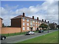
1
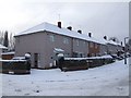
Council Housing - Bradburn Road
These houses on the early 1950s Long Knowle Estate have recently been renovated. A privately owned house shows the original brickwork finish. A feature of the low rise housing is the dwarf brick perimeter walls with brick on edge coping.
Image: © John M
Taken: 19 Dec 2010
0.14 miles
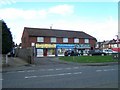
2
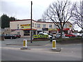
Shops in Prestwood Road West
Now largely given over to fast food outlets. The building is believed to date from the 1930s.
Image: © John M
Taken: 30 Mar 2013
0.18 miles
3
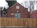
Electrical substation
The Midland Electricity Corporation Ltd with offices in Birmingham supplied power to an area of the Black Country from Bilston to Stourbridge. This substation in Wednesfield dating from the 1930s is on the fringe of their supply area.
The company was nationalised in 1947 as part of the Midlands Electricity Board.
Image: © John M
Taken: 30 Mar 2013
0.18 miles
4
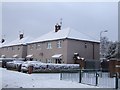
Council Housing - Bradburn Road
These houses on the early 1950s Long Knowle Estate have recently been renovated. Most are obviously still in Council ownership.
Image: © John M
Taken: 19 Dec 2010
0.19 miles
5
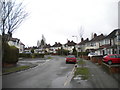
Willow Avenue, the Scotlands
Approaching the junction with Beechwood Avenue (left) from Cannock Road.
Image: © Richard Vince
Taken: 27 Dec 2017
0.21 miles
7
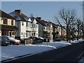
Private Housing - Mill Lane
Suburban 1930s housing.
Image: © John M
Taken: 9 Jan 2010
0.21 miles
8
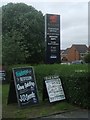
Signage at the Red Lion PH
Returned quickly to the original signage after England's swift exit in the knockout stage of the European Football Championships.
Image: © John M
Taken: 9 Jul 2016
0.21 miles
9
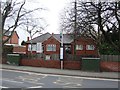
Doctors Surgery
A seven doctor practice in Prestwood Road West.
Image: © John M
Taken: 30 Mar 2013
0.21 miles
10
Council Housing - Long Knowle Estate
Early 1950s council housing in Guest Avenue. Original flat roof replaced by pitched roof in 1990s.
Image: © John M
Taken: 3 Sep 2006
0.22 miles