IMAGES TAKEN NEAR TO
Carlton Avenue, WOLVERHAMPTON, WV11 1DE
Introduction
This page details the photographs taken nearby to Carlton Avenue, WV11 1DE by members of the Geograph project.
The Geograph project started in 2005 with the aim of publishing, organising and preserving representative images for every square kilometre of Great Britain, Ireland and the Isle of Man.

There are currently over 7.5m images from over14,400 individuals and you can help contribute to the project by visiting https://www.geograph.org.uk
Image Map
Images are licensed for reuse under creativecommons.org/licenses/by-sa/2.0
Notes
- Clicking on the map will re-center to the selected point.
- The higher the marker number, the further away the image location is from the centre of the postcode.
Image Listing (21 Images Found)
Images are licensed for reuse under creativecommons.org/licenses/by-sa/2.0
Image
Details
Distance
1
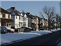
Private Housing - Mill Lane
Suburban 1930s housing.
Image: © John M
Taken: 9 Jan 2010
0.07 miles
3
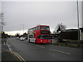
Bus on Cannock Road, Scotlands
National Express West Midlands 4548, a Dennis Trident/Alexander ALX400, passes the end of Mill Lane while working route 11 to Underhill estate. This bus is one of a batch of 75 such vehicles delivered to Wolverhampton in 2003-4, a truly massive investment that replaced more than a third of the then Travel West Midlands fleet in the city.
Image: © Richard Vince
Taken: 27 Dec 2017
0.14 miles
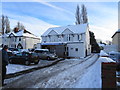
4
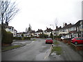
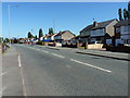
D'eyncourt Road
The view down the road in a Wolverhampton 1930s housing estate.
Image: © Gordon Griffiths
Taken: 11 Jul 2008
0.14 miles
6
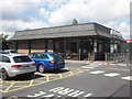
The drive-thru McDonald's on the Cannock Road
Much as I hate the spelling ('thru'), it is becoming the norm these days when associated with the word 'drive', especially for fast-food businesses. This is on the A460 Cannock Road in The Scotlands.
Image: © Richard Law
Taken: 7 Sep 2012
0.15 miles
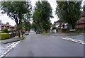
7
Willow Avenue, the Scotlands
Approaching the junction with Beechwood Avenue (left) from Cannock Road.
Image: © Richard Vince
Taken: 27 Dec 2017
0.15 miles
8
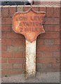
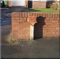
Old Milepost by the A460, Cannock Road, Old Fallings, Wolverhampton
Cast iron post by the A460, in parish of WOLVERHAMPTON (WOLVERHAMPTON District), Cannock Road; Old Fallings, just South of the junction of Croft and Leason Lanes, against garden wall of No. 677, on West side of road. Erected by an unknown authority in the 19th century.
Inscription reads:- : LOW LEVE(L) / STATION / 2 MILES :
Milestone Society National ID: ST_WVLL02
Image: © Mike Faherty
Taken: 13 Mar 2008
0.16 miles
9
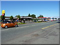
The A460 Cannock Road
1960s housing on the east side of the Cannock Road, heading out of Wolverhampton.
Image: © Richard Law
Taken: 7 Sep 2012
0.16 miles
10
'Low Level Station 2 Miles'
A rare surviving milepost from a bygone era.
The GWR station opened in 1854 and was the most northerly broad gauge station. It was re-named as Low Level in 1856 to distinguish it from the adjacent LMS High Level Station. The station closed to passenger traffic in 1972.
Image: © John M
Taken: 3 Jan 2010
0.17 miles