IMAGES TAKEN NEAR TO
Belton Avenue, WOLVERHAMPTON, WV11 1AJ
Introduction
This page details the photographs taken nearby to Belton Avenue, WV11 1AJ by members of the Geograph project.
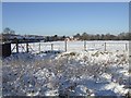
The Geograph project started in 2005 with the aim of publishing, organising and preserving representative images for every square kilometre of Great Britain, Ireland and the Isle of Man.

There are currently over 7.5m images from over14,400 individuals and you can help contribute to the project by visiting https://www.geograph.org.uk
Image Map
Images are licensed for reuse under creativecommons.org/licenses/by-sa/2.0
Notes
- Clicking on the map will re-center to the selected point.
- The higher the marker number, the further away the image location is from the centre of the postcode.
Image Listing (68 Images Found)
Images are licensed for reuse under creativecommons.org/licenses/by-sa/2.0
Image
Details
Distance
1
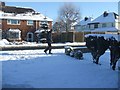
Man on a mission
11-55am on Christmas Day heading to take the mid-day picture.
Image: © John M
Taken: 25 Dec 2010
0.02 miles
2
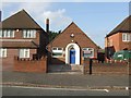
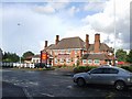
Doctor's Surgery, Blackhalve Lane
Built to serve a rapidly expanding population in the area.
Image: © John M
Taken: 20 Oct 2007
0.04 miles
3
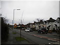
Blackhalve Lane, Scotlands
Looking towards Wood Hayes east of the Long Knowle Lane roundabout.
Image: © Richard Vince
Taken: 27 Dec 2017
0.09 miles
4
Former sports ground
The former Henry Meadows sports ground in Grassy Lane. Meadows manufactured auto and marine engines from 1922 to 1969, from 1964 owned by Jaguar. The cricket pavilion was soon demolished and the area used for rough grazing. Bordering the Green Belt it has so far escaped housing or other development.
Image: © John M
Taken: 25 Dec 2010
0.09 miles
5
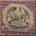
William Butler Brewery Emblem - Pear Tree Inn
The emblem over the main door into the 1937 pub. Image
William Butler's were taken over by Mitchells and Butlers of Smethwick in 1960. The Springfield Brewery in Wolverhampton suvived until 1991.
Image: © John M
Taken: 6 Jun 2010
0.10 miles
6
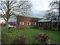
Church hall at St Gregory the Great
Polling station for the local elections in the former church on Blackhalve Lane.
Image: © John M
Taken: 1 May 2008
0.11 miles
7
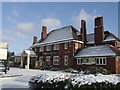
New Pear Tree Inn
A hostelry has stood on this site for many years. The current building was built in 1937 to serve the expansion in trade as the neighbouring Scotlands Estate and private housing developed. The pub marked the terminus of the trolleybus route. The licensee was Bert Adey the noted local boxer, trainer, second and promoter. Contests were held in the field behind the pub drawing crowds of up to 3000. Bert retired after almost half a century. The pub recently reverted to the Pear Tree name after several years as the Millhouse.
Image: © John M
Taken: 9 Jan 2010
0.11 miles
8
New Pear Tree Inn, Cannock Road
The 'Pear Tree Inn', a landmark on the town boundary, was until recently branded as the 'Millhouse'. It is refreshing to see that the new management chain has reverted to the original name. For many years this was the terminus for the trolleybuses with a turning circle in the Cannock Road.
Image: © John M
Taken: 26 Jul 2007
0.11 miles
9
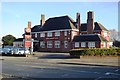
Berry Brook Farm (former New Pear Tree)
The pub has been closed for over a month to be refurbished and rebranded to the 'Farmhouse Inns' brand. Greene King acquired the pub as part of the takeover of the Spirit Pub Company in 2015.
The Berry Brook is the old name for the nearby Waterhead Brook and was also used to rebrand the Underhill Primary School.
Image: © John M
Taken: 4 Dec 2016
0.12 miles