IMAGES TAKEN NEAR TO
Fifth Avenue, WOLVERHAMPTON, WV10 9SY
Introduction
This page details the photographs taken nearby to Fifth Avenue, WV10 9SY by members of the Geograph project.
The Geograph project started in 2005 with the aim of publishing, organising and preserving representative images for every square kilometre of Great Britain, Ireland and the Isle of Man.

There are currently over 7.5m images from over14,400 individuals and you can help contribute to the project by visiting https://www.geograph.org.uk
Image Map
Images are licensed for reuse under creativecommons.org/licenses/by-sa/2.0
Notes
- Clicking on the map will re-center to the selected point.
- The higher the marker number, the further away the image location is from the centre of the postcode.
Image Listing (19 Images Found)
Images are licensed for reuse under creativecommons.org/licenses/by-sa/2.0
Image
Details
Distance
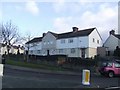
1
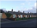
Council Housing - Goodyear Avenue
Wolverhampton Council purchased the Oldfallings and Showell Estates for housing after the Great War. These were developed into large housing estates between 1924 and 1927. These houses in a triangular block bounded by Goodyear Avenue and Second Avenue probably date from the 1960s.
Goodyear opened their plant on the Stafford Road in 1927. Road names also include Wingfoot Avenue.
Image: © John M
Taken: 13 Dec 2009
0.04 miles
2
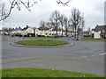
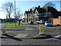
Roundabout in Low Hill
One of a series of small roundabouts in the Low Hill estate; this particular one being at the junction of Fifth Avenue with First and Goodyear Avenues.
Image: © Richard Law
Taken: 16 Mar 2012
0.05 miles
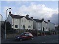
3

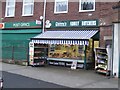
R. A. Cartwright - Traditional Family Butcher
The sign reads 'Purveyors of English and Scotch Meats'. This is one of a two butchers shops at Showell Circus. The Circus marks the centre of a large 1920s council housing estate.
Image: © John M
Taken: 28 Nov 2009
0.07 miles
4
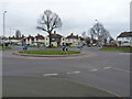
Roundabout near Old Fallings
A mini roundabout in the Low Hill estate, at the junction of Fifth Avenue with Dickinson and Third Avenues.
Image: © Richard Law
Taken: 16 Mar 2012
0.09 miles
5
Danny's Family Butchers
This is one of a two butchers shops at Showell Circus. The Circus marks the centre of a large 1920s council housing estate.
Image: © John M
Taken: 28 Nov 2009
0.11 miles
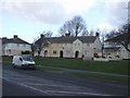
6
Council Housing - Old Fallings Crescent
Wolverhampton Council purchased the Oldfallings and Showell Estates for housing after the Great War. These were developed into large housing estates between 1924 and 1927. The house designs were similar to those used at the small development at Sweetman Street in 1923. Image Various renovation schemes have been carried out with plastic cladding attached to the upper storey.
Image: © John M
Taken: 13 Dec 2009
0.12 miles
7
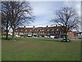
New village green at Low Hill
A twenty three year campaign has been waged to protect the large traffic island, Showell Circus, in the heart of this pre-war estate of council housing from development. Following a recent planning application from a retail outlet the traffic island has now been awarded village green status. It is believed that this is the first traffic island in the country to be awarded such status.
The qualification criteria and protection to village greens were amended by Section 15 of the Commons Act 2006. Once registered, it is protected from encroachment and development by section 12 of the Inclosure Act 1845 and section 29 of the Commons Act 1876. Local people have a right to enjoy the land for recreation.
Image: © John M
Taken: 12 Apr 2008
0.12 miles
8
Council Housing - Second Avenue
Wolverhampton Council purchased the Oldfallings and Showell Estates for housing after the Great War. These were developed into large housing estates between 1924 and 1927. The house designs were similar to those used at the smaller developments at Sweetman Street Image and Old Heath Image This is the semi-detached version of the design.
Road naming on the estate was unimaginative.
Image: © John M
Taken: 13 Dec 2009
0.13 miles
9
Council Housing - Third Avenue
Wolverhampton Council purchased the Oldfallings and Showell Estates for housing after the Great War. These were developed into large housing estates between 1924 and 1927. The house designs were similar to those used at the smaller developments at Sweetman Street Image and Old Heath Image Alternate blocks were built in each style. Various renovation schemes have been carried out with many of the houses having plastic cladding attached to the upper storey.
Road naming on the estate was unimaginative.
Image: © John M
Taken: 13 Dec 2009
0.15 miles
10
Showell Circus Pub
The Bushbury Arms viewed from Jenks Avenue.
Image: © Gordon Griffiths
Taken: 30 Jan 2008
0.16 miles