IMAGES TAKEN NEAR TO
Wolseley Bank, WOLVERHAMPTON, WV10 9QS
Introduction
This page details the photographs taken nearby to Wolseley Bank, WV10 9QS by members of the Geograph project.
The Geograph project started in 2005 with the aim of publishing, organising and preserving representative images for every square kilometre of Great Britain, Ireland and the Isle of Man.

There are currently over 7.5m images from over14,400 individuals and you can help contribute to the project by visiting https://www.geograph.org.uk
Image Map
Images are licensed for reuse under creativecommons.org/licenses/by-sa/2.0
Notes
- Clicking on the map will re-center to the selected point.
- The higher the marker number, the further away the image location is from the centre of the postcode.
Image Listing (46 Images Found)
Images are licensed for reuse under creativecommons.org/licenses/by-sa/2.0
Image
Details
Distance
1
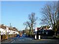
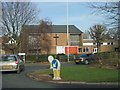
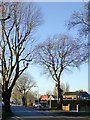
Old Fallings Lane at Newbolds, Wolverhampton
Looking north towards Bushbury from the Cannock Road (A460) roundabout.
Image: © Roger D Kidd
Taken: 20 Jan 2017
0.04 miles
2
Old Fallings Lane at Newbolds, Wolverhampton
Looking north towards Bushbury from the Cannock Road (A460) roundabout.
Image: © Roger D Kidd
Taken: 20 Jan 2017
0.05 miles
3
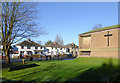
Church in Old Fallings Lane, Wolverhampton
This is part of the Old Fallings United Reformed Church seen from Cannock Road.
Image: © Roger D Kidd
Taken: 20 Jan 2017
0.05 miles
4
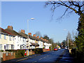
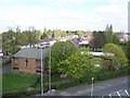
Housing in Old Fallings Lane, Wolverhampton
Looking north towards Bushbury from near the United Reformed Church.
Image: © Roger D Kidd
Taken: 20 Jan 2017
0.05 miles
5
Old Fallings United Reformed Church
The church hall was used for a time as additional classroom space for St Mary's Catholic Primary School across the road.
Image: © John M
Taken: 4 Feb 2007
0.06 miles
6
Old Fallings United Reformed Church
Taken from the tower of Our Lady Of Perpetual Succour RC Church
Image: © Geoff Pick
Taken: 11 Apr 2011
0.06 miles
7
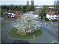
Roundabout At Newbolds
Taken from the tower of Our Lady Of Perpetual Succour RC Church
Image: © Geoff Pick
Taken: 11 Apr 2011
0.09 miles
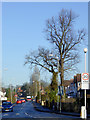
8
Cannock Road at Newbolds, Wolverhampton
This is the A460 approaching the roundabout at Newbolds, looking north across to the white houses in Old Fallings Lane.
Image: © Roger D Kidd
Taken: 20 Jan 2017
0.10 miles
9
Park Lane near Newbolds, Wolverhampton
Looking south-west towards Park Village from near the Cannock Road.
Image: © Roger D Kidd
Taken: 20 Jan 2017
0.10 miles
10

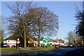
Fifth Avenue at Old Fallings in Wolverhampton
Looking west towards Showell Road from near the junction with Old Fallings Lane.
Image: © Roger D Kidd
Taken: 6 Aug 2024
0.10 miles