IMAGES TAKEN NEAR TO
Wolseley Gate, WOLVERHAMPTON, WV10 9QP
Introduction
This page details the photographs taken nearby to Wolseley Gate, WV10 9QP by members of the Geograph project.
The Geograph project started in 2005 with the aim of publishing, organising and preserving representative images for every square kilometre of Great Britain, Ireland and the Isle of Man.

There are currently over 7.5m images from over14,400 individuals and you can help contribute to the project by visiting https://www.geograph.org.uk
Image Map
Images are licensed for reuse under creativecommons.org/licenses/by-sa/2.0
Notes
- Clicking on the map will re-center to the selected point.
- The higher the marker number, the further away the image location is from the centre of the postcode.
Image Listing (52 Images Found)
Images are licensed for reuse under creativecommons.org/licenses/by-sa/2.0
Image
Details
Distance
1
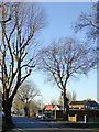
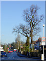
Park Lane near Newbolds, Wolverhampton
Looking south-west towards Park Village from near the Cannock Road.
Image: © Roger D Kidd
Taken: 20 Jan 2017
0.02 miles
2
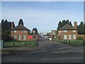
Entrance to TA Headquarters
Regimental Headquarters of 'The West Midlands Regiment'
Image: © John M
Taken: 4 Feb 2007
0.05 miles
3
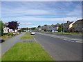
Fallings Park, Third Avenue
Several local roads are named after ordinal numbers.
Image: © Mike Faherty
Taken: 30 Jun 2013
0.06 miles
4
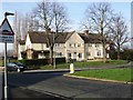
Council Housing - Park Lane
1920s style block on the corner plot with Third Avenue.
Image: © John M
Taken: 13 Jan 2013
0.06 miles
5
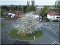
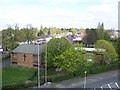
Roundabout At Newbolds
Taken from the tower of Our Lady Of Perpetual Succour RC Church
Image: © Geoff Pick
Taken: 11 Apr 2011
0.07 miles
6
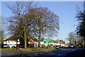
Cannock Road at Newbolds, Wolverhampton
This is the A460 approaching the roundabout at Newbolds, looking north across to the white houses in Old Fallings Lane.
Image: © Roger D Kidd
Taken: 20 Jan 2017
0.07 miles
7
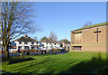
Church in Old Fallings Lane, Wolverhampton
This is part of the Old Fallings United Reformed Church seen from Cannock Road.
Image: © Roger D Kidd
Taken: 20 Jan 2017
0.10 miles
8
Fallings Park, medical centre
Raynor Road Medical Centre, at the corner of Raynor and Inchlaggan Roads: http://www.raynorroadmedicalcentre.co.uk/
Image: © Mike Faherty
Taken: 30 Jun 2013
0.10 miles
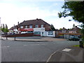
9
Old Fallings Lane at Newbolds, Wolverhampton
Looking north towards Bushbury from the Cannock Road (A460) roundabout.
Image: © Roger D Kidd
Taken: 20 Jan 2017
0.10 miles
10
Old Fallings United Reformed Church
Taken from the tower of Our Lady Of Perpetual Succour RC Church
Image: © Geoff Pick
Taken: 11 Apr 2011
0.12 miles