IMAGES TAKEN NEAR TO
Bank Street, WOLVERHAMPTON, WV10 9DU
Introduction
This page details the photographs taken nearby to Bank Street, WV10 9DU by members of the Geograph project.
The Geograph project started in 2005 with the aim of publishing, organising and preserving representative images for every square kilometre of Great Britain, Ireland and the Isle of Man.

There are currently over 7.5m images from over14,400 individuals and you can help contribute to the project by visiting https://www.geograph.org.uk
Image Map
Images are licensed for reuse under creativecommons.org/licenses/by-sa/2.0
Notes
- Clicking on the map will re-center to the selected point.
- The higher the marker number, the further away the image location is from the centre of the postcode.
Image Listing (17 Images Found)
Images are licensed for reuse under creativecommons.org/licenses/by-sa/2.0
Image
Details
Distance
1
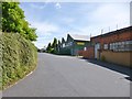
Fallings Park Industrial Estate
The entrance to one of Wolverhampton's many industrial parks
Image: © Richard Law
Taken: 24 Nov 2010
0.09 miles
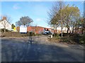
2
Park Village, youth centre
Park Village Youth, Media & Activity Centre, at the corner of Cannock Road and Park Lane: https://www.facebook.com/pages/Park-Village-Youth-and-Media-Centre/221447827963020?sk=page_map
Image: © Mike Faherty
Taken: 30 Jun 2013
0.10 miles
3
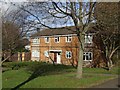
Council Housing - Leslie Street
Small infill estate of houses beside the Cannock Road in Park Village probably dating from the mid 1970s.
Image: © John M
Taken: 13 Nov 2010
0.11 miles
4
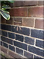
OS benchmark, Park Village former school
An OS cutmark on the front wall of the former school, now the Park Village Youth, Media & Activity Centre (although I have to say, it looked pretty firmly closed the day I passed). Mark originally levelled at 128.571m above Ordnance Datuim Newlyn.
Image: © Richard Law
Taken: 5 Feb 2015
0.12 miles
5
Fallings Park, Guy Motors Industrial Park
Off Park Lane, presumably on the site of the former bus and lorry makers.
Image: © Mike Faherty
Taken: 30 Jun 2013
0.12 miles
6
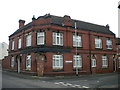
Former pub, Stratton Street, Park Village
On the corner of Prosser Street. Now apparently converted into flats.
Image: © Richard Vince
Taken: 27 Dec 2017
0.13 miles
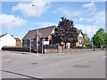
7
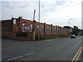
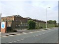
Guy Motors, Park Village
Founded by Sidney Guy in 1913 the company produced military vehicles during the First World War. Between the wars Guy Motors built commercial vehicles, coaches and trolleybuses. They were unsuccessful with car production. During the Second World War they were the only company with spare capacity available to build buses. They ran into difficulties in the 1950s as trolleybuses went out of fashion and their other bus designs became dated. The firm went into receivership in 1961, eventually being taken over by Jaguar before coming under BMC. Production or assembly continued on the site until the 1970s. Most of the original buildings have been demolished. Part of the site is now used as an industrial estate.
Image: © John M
Taken: 30 Sep 2007
0.13 miles
8
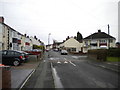
Swinford Road, Park Village
Seen from Prosser Street.
Image: © Richard Vince
Taken: 27 Dec 2017
0.17 miles
9
North end of Prosser Street, Park Village
Image: © Richard Vince
Taken: 27 Dec 2017
0.17 miles
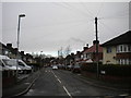
10
Bus Garage, Park Lane
The bus depot was directly across the road from Guy Motors, the main supplier of buses and trolleybuses to the Corporation fleet. The close connection lasted for many years. It remains a large bus garage used by Travel WM successor to Wolverhampton Corporation Transport Department. The other bus garage in Cleveland Street closed some years ago.
Image: © John M
Taken: 30 Sep 2007
0.17 miles