IMAGES TAKEN NEAR TO
Hillstone Gardens, WOLVERHAMPTON, WV10 9DN
Introduction
This page details the photographs taken nearby to Hillstone Gardens, WV10 9DN by members of the Geograph project.
The Geograph project started in 2005 with the aim of publishing, organising and preserving representative images for every square kilometre of Great Britain, Ireland and the Isle of Man.

There are currently over 7.5m images from over14,400 individuals and you can help contribute to the project by visiting https://www.geograph.org.uk
Image Map
Images are licensed for reuse under creativecommons.org/licenses/by-sa/2.0
Notes
- Clicking on the map will re-center to the selected point.
- The higher the marker number, the further away the image location is from the centre of the postcode.
Image Listing (56 Images Found)
Images are licensed for reuse under creativecommons.org/licenses/by-sa/2.0
Image
Details
Distance
1
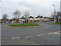
Roundabout in Bushbury
A roundabout on the Low Hill estate, at the junction of Whitgreave Avenue with Dickinson and Leacroft Avenues.
Image: © Richard Law
Taken: 16 Mar 2012
0.08 miles
2
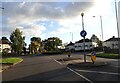
Kempthorne Avenue Island
The view in Bushbury, Wolverhampton.
Image: © Gordon Griffiths
Taken: 4 Nov 2021
0.14 miles
3
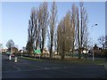
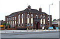
The changing face of Showell Circus
The disused Methodist church Image has recently been demolished. What will appear in its place?
Image: © John M
Taken: 5 Jan 2008
0.15 miles
4
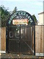
The Magic Garden, Bushbury
The secrets of the Magic Garden remain undiscovered as the gates were locked tight!
Image: © John M
Taken: 5 Nov 2006
0.15 miles
5
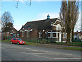
The New Highcroft, Old Fallings, Wolverhampton
The pub was originally the "Highcroft". This was changed to "The Moon Under Water" when new management was introduced. The pub's name was changed yet again to "The New Highcroft" when more new management was introduced.
The pub was put up for sale for £600,000 in February 2010 "subject to an occupational tenancy until 2011 at the (then) current rent of £18,302 per annum."
Update: This pub has been closed, sold, and is to be demolished in 2011 so that a new care home can be built.
Update 6 April 2011 Image
Image: © Roger Kidd
Taken: 7 Jun 2007
0.16 miles
6
Low Hill Methodist Church from Showell Circus
The church suffered from dry rot and has been closed down. It is expected it will be demolished in the near future.
Image: © Mike Jackson
Taken: 20 Feb 2005
0.16 miles
7
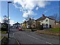
St Chads Road in Oldfallings, Wolverhampton
St Chads (sic) Road is a short cul-de-sac off Old Fallings Lane. The council would have reprimanded me if Ofsted had reported me for poor teaching of correct apostrophe usage. http://www.geograph.org.uk/photo/3696873
Image: © Roger D Kidd
Taken: 8 Mar 2018
0.17 miles
8
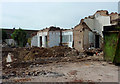
Last walls standing of The New Highcroft, Wolverhampton
Image: © Roger D Kidd
Taken: 6 Apr 2011
0.17 miles
9
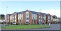
Highcroft Hall Residential Home, Wolverhampton
Image: © Roger D Kidd
Taken: 3 Oct 2012
0.17 miles
10
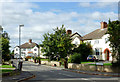
St Chad's Road in Oldfallings, Wolverhampton
A short cul-de-sac off Old Fallings Lane with semi-detached freehold houses. Sadly, it seems the authority has seen fit to drop the apostrophe, while insisting that its correct use is taught in its schools.
Image: © Roger D Kidd
Taken: 10 Oct 2013
0.18 miles