IMAGES TAKEN NEAR TO
Webley Rise, WOLVERHAMPTON, WV10 8UH
Introduction
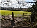
This page details the photographs taken nearby to Webley Rise, WV10 8UH by members of the Geograph project.
The Geograph project started in 2005 with the aim of publishing, organising and preserving representative images for every square kilometre of Great Britain, Ireland and the Isle of Man.

There are currently over 7.5m images from over14,400 individuals and you can help contribute to the project by visiting https://www.geograph.org.uk
Image Map
Images are licensed for reuse under creativecommons.org/licenses/by-sa/2.0
Notes
- Clicking on the map will re-center to the selected point.
- The higher the marker number, the further away the image location is from the centre of the postcode.
Image Listing (41 Images Found)
Images are licensed for reuse under creativecommons.org/licenses/by-sa/2.0
Image
Details
Distance
1
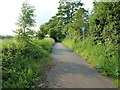
Legs Lane from Northycote Lane, Fordhouses
Image: © Mick Malpass
Taken: 10 Sep 2011
0.04 miles
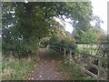
2
Monarch's Way
Path Junction at Northycote Farm.
Image: © Gordon Griffiths
Taken: 30 Jan 2008
0.08 miles
3
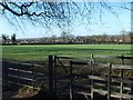
Bridleway north of Northycote Farm
The bridleway splits fairly soon after this point, with one branch (Northycote Lane) continuing NNW to join Cat & Kittens Lane, and the other heading slightly NNE to Moseley Road.
Image: © Richard Law
Taken: 18 Jun 2014
0.11 miles
4
Along the Monarch's Way
The Monarch's Way from Moseley Old Hall to Northycote Farm with the Country Park on the right.
Image: © John M
Taken: 18 Oct 2008
0.12 miles
5
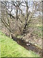
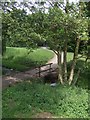
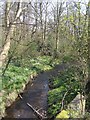
Waterhead Brook at Moseley
From its source near Essington the Waterhead Brook, a tributary of the River Penk, flows through the edge of Wolverhampton to Coven. Sections near habitation suffer from fly tipping. The flow in dry periods can be very low but water was impounded and powered a couple of watermills.
Image: © John M
Taken: 17 Apr 2010
0.14 miles
6
Waterhead Brook emerges at Northycote Lane
The Waterhead Brook is a tributary of the River Penk.
Image: © John M
Taken: 17 Apr 2010
0.14 miles
7
Waterhead Brook upstream at Moseley Court
Downstream of the mill site and pool in the Country Park near Moseley Court.
Image: © John M
Taken: 17 Apr 2010
0.15 miles
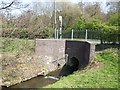
8
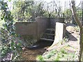
Waterhead Brook Culvert inlet at Northycote Lane
A heavy duty grille prevents large items obstructing the flow.
Image: © John M
Taken: 17 Apr 2010
0.15 miles