IMAGES TAKEN NEAR TO
Primrose Lane, WOLVERHAMPTON, WV10 8RN
Introduction
This page details the photographs taken nearby to Primrose Lane, WV10 8RN by members of the Geograph project.
The Geograph project started in 2005 with the aim of publishing, organising and preserving representative images for every square kilometre of Great Britain, Ireland and the Isle of Man.

There are currently over 7.5m images from over14,400 individuals and you can help contribute to the project by visiting https://www.geograph.org.uk
Image Map
Images are licensed for reuse under creativecommons.org/licenses/by-sa/2.0
Notes
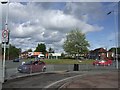
- Clicking on the map will re-center to the selected point.
- The higher the marker number, the further away the image location is from the centre of the postcode.
Image Listing (44 Images Found)
Images are licensed for reuse under creativecommons.org/licenses/by-sa/2.0
Image
Details
Distance
1
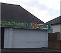
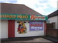
Re-branded outlet at 'The Scotlands'
Image: © John M
Taken: 27 Mar 2011
0.03 miles
2
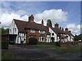
Council Housing - Pre-war housing in Primrose Lane
These council built properties from late 1930s retain many of their original features. They were the larger design with parlours for rent at 15/1 per week. Larger houses on the fringes of the estates were often sold to private owners.
Image: © John M
Taken: 7 May 2007
0.03 miles
3
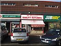
P Davies - Quality Butchers
The last surviving butchers shop at the Scotlands has little local competition. The local shopping centre is now predominantly a fast food haven with Subway as the most recent addition.
Image: © John M
Taken: 7 Nov 2009
0.03 miles
4
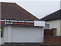
Invitation withdrawn at The Scotlands?
The somewhat tasteless sign shown on Image has been removed.
Image: © John M
Taken: 8 Nov 2009
0.04 miles
6
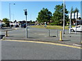
Roundabout on the Cannock Road
On the A460 at The Scotlands.
Image: © Richard Law
Taken: 7 Sep 2012
0.07 miles
7
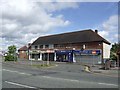
Pre-war parade of shops at 'The Scotlands'
The shops date from 1937 and are contemporary with the large council estates that were built by Wolverhampton Council in the 1930s.
Image: © John M
Taken: 7 May 2007
0.07 miles
8
The drive-thru McDonald's on the Cannock Road
Much as I hate the spelling ('thru'), it is becoming the norm these days when associated with the word 'drive', especially for fast-food businesses. This is on the A460 Cannock Road in The Scotlands.
Image: © Richard Law
Taken: 7 Sep 2012
0.07 miles
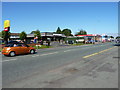
9
'The Scotlands' Roundabout
The large roundabout was constructed in the 1960s with a single high mast lighting the whole area, this disappeared some time ago. Shops and pubs have been replaced by fast food outlets.
Image: © John M
Taken: 7 May 2007
0.07 miles
10
Polling Station - Wolverhampton North East
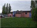
Polling station for the 2010 General Election at the Scotlands Adventure Playground. The polling station serves a 1930s Council Estate with some houses bought under 'Right to Buy' schemes. The demographic is working class with social deprivation and high unemployment.
Image: © John M
Taken: 6 May 2010
0.07 miles