IMAGES TAKEN NEAR TO
Wildtree Avenue, WOLVERHAMPTON, WV10 8NL
Introduction
This page details the photographs taken nearby to Wildtree Avenue, WV10 8NL by members of the Geograph project.
The Geograph project started in 2005 with the aim of publishing, organising and preserving representative images for every square kilometre of Great Britain, Ireland and the Isle of Man.

There are currently over 7.5m images from over14,400 individuals and you can help contribute to the project by visiting https://www.geograph.org.uk
Image Map
Images are licensed for reuse under creativecommons.org/licenses/by-sa/2.0
Notes
- Clicking on the map will re-center to the selected point.
- The higher the marker number, the further away the image location is from the centre of the postcode.
Image Listing (44 Images Found)
Images are licensed for reuse under creativecommons.org/licenses/by-sa/2.0
Image
Details
Distance
1
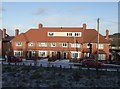
Council Housing - Keats Road
On the outer edge of the 1937 Scotlands Estate taken from the site of the demolished Barrie Crescent. The houses look out towards Bushbury Hill.
Elsewhere on the estate there are properties similar to the central pair of houses and semi-detached houses similar to the end units. The roof line is a little curious and the dormer windows in the roof space appear to be a much later addition.
Image: © John M
Taken: 20 Dec 2009
0.03 miles
2
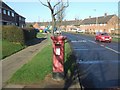
Post war council housing on Underhill Estate
The George VI postbox on Underhill Lane is contemporary with the housing. A large proportion of this housing has transferred into private ownership under 'right to buy'. The housing on the right hand side of the road was built in the late 1940s and is some of the earliest post-war housing in the town. The housing on the left dates from a few years later.
Image: © John M
Taken: 3 Feb 2007
0.10 miles
4
Council Housing - Underhill Lane
Walk-in igloo on the 1950s Underhill Estate.
Image: © John M
Taken: 11 Dec 2017
0.11 miles
5
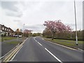
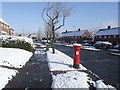
Underhill Lane
The view in Bushbury, Wolverhampton.
Image: © Gordon Griffiths
Taken: 1 May 2015
0.11 miles
6
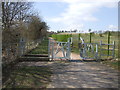
Footpath to Bushbury Hill
Diverted footpath avoiding the recent extension to Bushbury Crematorium.
Image: © John M
Taken: 6 Apr 2013
0.12 miles
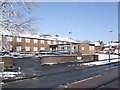
7
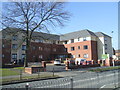
Wulfrun Rose Nursing Home
A privately run Care Home on the site of Underhill House opened in February 2016.
Image: © John M
Taken: 13 Mar 2016
0.12 miles
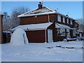
9
View to Wildtree Avenue
Dropping down from Bushbury Hill towards the Underhill Estate in the first snow of the winter.
Image: © John M
Taken: 9 Dec 2017
0.14 miles
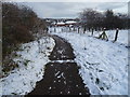
10
Underhill House
Council operated home recently reprieved from closure after review.
The reprieve was relatively short-lived as the home closed in January 2010 amidst some uproar as 106 year old Louisa Watts was moved to another home on one of the coldest days of the winter.
A new private care home opened on the site in February 2016.
Image: © John M
Taken: 6 Apr 2008
0.14 miles