IMAGES TAKEN NEAR TO
Grosvenor Road, WOLVERHAMPTON, WV10 8JA
Introduction
This page details the photographs taken nearby to Grosvenor Road, WV10 8JA by members of the Geograph project.
The Geograph project started in 2005 with the aim of publishing, organising and preserving representative images for every square kilometre of Great Britain, Ireland and the Isle of Man.

There are currently over 7.5m images from over14,400 individuals and you can help contribute to the project by visiting https://www.geograph.org.uk
Image Map
Images are licensed for reuse under creativecommons.org/licenses/by-sa/2.0
Notes
- Clicking on the map will re-center to the selected point.
- The higher the marker number, the further away the image location is from the centre of the postcode.
Image Listing (22 Images Found)
Images are licensed for reuse under creativecommons.org/licenses/by-sa/2.0
Image
Details
Distance
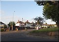
1
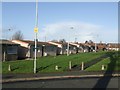
Council Housing - Lincoln Green
Immediate post war prefabricated homes dating from around 1947. Although Wolverhampton had lost a relatively small number of properties to bombing the council still erected a large number of these temporary dwellings. Surprisingly a fair proportion of these remain scattered around the city despite their original ten year design life.
Image: © John M
Taken: 6 Dec 2009
0.04 miles
2
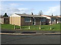
Council Housing - Lincoln Green
Immediate post war prefabricated homes dating from around 1947. Although Wolverhampton had lost a relatively small number of properties to bombing the council still erected a large number of these temporary dwellings. Surprisingly a fair proportion of these remain scattered around the city despite their original ten year design life.
Image: © John M
Taken: 6 Dec 2009
0.05 miles
3
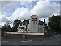
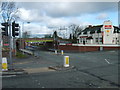
The Woodbine
The large retaining wall in front of the pub was built to allow Elston Hall Road to be lowered and re-aligned to pass under the new railway bridge.
Image: © John M
Taken: 7 May 2007
0.19 miles
4
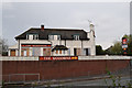
The Woodbine, Elston Hall Lane
Evidently a pub which has known better times
Image: © Keith Edkins
Taken: 6 Nov 2014
0.21 miles
6
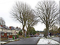
Three Tuns Lane near Bushbury in Wolverhampton
Looking east-south-east towards Elston Hall and Bushbury. The snow is a remnant of the 6-8cm which fell during Storm Arwen three days before.
Image: © Roger Kidd
Taken: 29 Nov 2021
0.22 miles
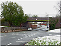
7
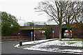
Railway bridge near Elston Hall in Wolverhampton
The West Coast Main Line from Manchester, Stoke-on-Trent and Stafford crosses Three Tuns Lane here, seen from Church Road. The snow is a remnant of the 6-8cm dumped by Storm Arwen three days earlier.
Image: © Roger Kidd
Taken: 29 Nov 2021
0.22 miles
8
Railway bridge near Elston Hall in Wolverhampton
The line from Stoke-on-Trent and Stafford crosses Three Tuns Lane here, seen from Church Road. The snow is a remnant of the 6-8cm dumped by Storm Arwen three days earlier.
Image: © Roger Kidd
Taken: 29 Nov 2021
0.22 miles
9
Elston Hall Lane at the corner of Fordhouse Lane
Image: © David Howard
Taken: 3 Jun 2018
0.22 miles
10
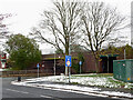
Three Tuns Lane near Elston Hall in Wolverhampton
Looking east-south-east towards Low Hill and Old Fallings.
The West Coast Main Line from Manchester, Stoke-on-Trent and Stafford crosses here. Beyond the bridge, the road becomes Elston Hall Lane.
Image: © Roger Kidd
Taken: 29 Nov 2021
0.23 miles