IMAGES TAKEN NEAR TO
School Lane, WOLVERHAMPTON, WV10 8HX
Introduction
This page details the photographs taken nearby to School Lane, WV10 8HX by members of the Geograph project.
The Geograph project started in 2005 with the aim of publishing, organising and preserving representative images for every square kilometre of Great Britain, Ireland and the Isle of Man.

There are currently over 7.5m images from over14,400 individuals and you can help contribute to the project by visiting https://www.geograph.org.uk
Image Map
Images are licensed for reuse under creativecommons.org/licenses/by-sa/2.0
Notes
- Clicking on the map will re-center to the selected point.
- The higher the marker number, the further away the image location is from the centre of the postcode.
Image Listing (30 Images Found)
Images are licensed for reuse under creativecommons.org/licenses/by-sa/2.0
Image
Details
Distance
1

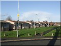
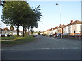
Council Housing - Lincoln Green
Immediate post war prefabricated homes dating from around 1947. Although Wolverhampton had lost a relatively small number of properties to bombing the council still erected a large number of these temporary dwellings. Surprisingly a fair proportion of these remain scattered around the city despite their original ten year design life.
Image: © John M
Taken: 6 Dec 2009
0.08 miles
2
Council Housing - Lincoln Green
Immediate post war prefabricated homes dating from around 1947. Although Wolverhampton had lost a relatively small number of properties to bombing the council still erected a large number of these temporary dwellings. Surprisingly a fair proportion of these remain scattered around the city despite their original ten year design life.
Image: © John M
Taken: 6 Dec 2009
0.09 miles
3
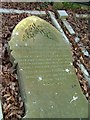
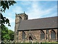
St Mary's Church Bushbury
Grave of Francis Henry Davies, killed in the railway accident at Portobello Junction 19th October 1899. He was Fireman of the express that collided with a goods train. Gravestone flat on ground.
Image: © Ray Durrant
Taken: 20 Mar 2009
0.19 miles
4
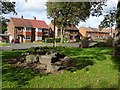
The Warriors Tomb, Bushbury
Interesting what can be discovered when exploring, this appeared to be nothing more than a collection of rocks, however, a little research has revealed that it is known as the 'Warriors Tomb'. The rocks are thought to be a memorial to those killed at The Battle of Tettenhall (also known as the Battle of Wednesfield or Wōdnesfeld), which took place on 5 August 910. A battle where the Danes were defeated by the combined forces of the Kingdoms of Wessex and Mercia under the leadership of Edward the Elder of Wessex and Aethelflaed, Lady of the Mercians. They were brother and sister, their father was Alfred the Great.
Image: © Philip Halling
Taken: 9 Oct 2019
0.20 miles
5
Bushbury Nursery School
The Bushbury Church School was established on this site in 1835.
Image: © John M
Taken: 17 Jan 2010
0.20 miles
6
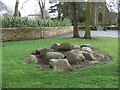
The Warrior's Tomb - Bushbury
In 910 Saxon Queen Ethelfleda's Mercian and her brother Edward's Wessex armies defeated a Viking army at the battle of Wodensfelde killing two Viking kings and inflicting a crushing victory over the invaders. This was a turning point in the struggle with the Danes and end of the Danelaw.
The location of the battle is unknown, variously linked with Tettenhall and Wednesfield. The significance of this pile of stones is unclear but is near to the Parish Church. It is unmarked and even as a local I had assumed this was merely a rockery.
Image: © John M
Taken: 29 Mar 2015
0.20 miles
10
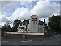
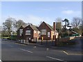
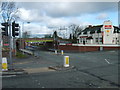
The Woodbine
The large retaining wall in front of the pub was built to allow Elston Hall Road to be lowered and re-aligned to pass under the new railway bridge.
Image: © John M
Taken: 7 May 2007
0.22 miles