IMAGES TAKEN NEAR TO
Ireton Road, WOLVERHAMPTON, WV10 8AG
Introduction
This page details the photographs taken nearby to Ireton Road, WV10 8AG by members of the Geograph project.
The Geograph project started in 2005 with the aim of publishing, organising and preserving representative images for every square kilometre of Great Britain, Ireland and the Isle of Man.

There are currently over 7.5m images from over14,400 individuals and you can help contribute to the project by visiting https://www.geograph.org.uk
Image Map
Images are licensed for reuse under creativecommons.org/licenses/by-sa/2.0
Notes
- Clicking on the map will re-center to the selected point.
- The higher the marker number, the further away the image location is from the centre of the postcode.
Image Listing (16 Images Found)
Images are licensed for reuse under creativecommons.org/licenses/by-sa/2.0
Image
Details
Distance
1
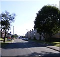
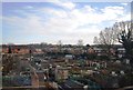
Primrose Avenue
The view in Fordhouses, Wolverhampton.
Image: © Gordon Griffiths
Taken: 12 Sep 2009
0.03 miles
2
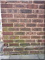
OS benchmark - Bushbury, 42 Primrose Avenue
An OS cutmark on the wall of a house on Primrose Avenue, originally levelled at 117.625m above Ordnance Datum Newlyn in 1963.
Image: © Richard Law
Taken: 1 Mar 2016
0.04 miles
3
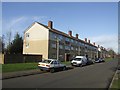
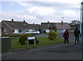
Council Housing - Primrose Avenue
A series of 1950s blocks backing on to the railway.
Image: © John M
Taken: 6 Dec 2009
0.06 miles
4
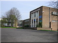
The Northicote High School
This school is now surrounded by a high metal fence. It used to be surrounded by a large open area.
Image: © Angella Streluk
Taken: 22 Apr 2006
0.07 miles
7
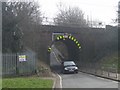
Bee Lane Bridge
Typical of the low headroom arch bridges under the LMR line north of Wolverhampton. This bridge has recently been struck.
Image: © John M
Taken: 7 Mar 2009
0.16 miles
8
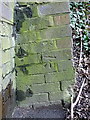
OS benchmark - Fordhouses, Bee Lane railway bridge
An OS cutmark on the abutment of the railway bridge; originally levelled at 114.437m above Ordnance Datum Newlyn.
Image: © Richard Law
Taken: 1 Mar 2016
0.16 miles
9
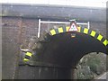
Bee Lane - Nibbling at the arch
Yet another driver of a high vehicle has taken a shortcut and misjudged the 10'6"clearance.Image] Luckily for rail travellers on the West Coast Main Line the damage was minor.
Image: © John M
Taken: 7 Mar 2009
0.16 miles
10
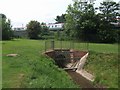
Waterhead Brook culvert under the railway
The brook disappears under the railway. It next emerges on the west side of the Stafford Road.
Image: © John M
Taken: 6 Jun 2010
0.17 miles