IMAGES TAKEN NEAR TO
Carisbrooke Road, WOLVERHAMPTON, WV10 8AB
Introduction
This page details the photographs taken nearby to Carisbrooke Road, WV10 8AB by members of the Geograph project.
The Geograph project started in 2005 with the aim of publishing, organising and preserving representative images for every square kilometre of Great Britain, Ireland and the Isle of Man.

There are currently over 7.5m images from over14,400 individuals and you can help contribute to the project by visiting https://www.geograph.org.uk
Image Map
Images are licensed for reuse under creativecommons.org/licenses/by-sa/2.0
Notes
- Clicking on the map will re-center to the selected point.
- The higher the marker number, the further away the image location is from the centre of the postcode.
Image Listing (20 Images Found)
Images are licensed for reuse under creativecommons.org/licenses/by-sa/2.0
Image
Details
Distance
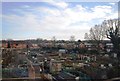
2
Council Housing - Primrose Avenue
A series of 1950s blocks backing on to the railway.
Image: © John M
Taken: 6 Dec 2009
0.11 miles
3
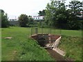
Waterhead Brook culvert under the railway
The brook disappears under the railway. It next emerges on the west side of the Stafford Road.
Image: © John M
Taken: 6 Jun 2010
0.12 miles
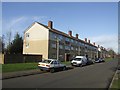
4
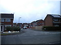
Primrose Avenue
The view in Fordhouses, Wolverhampton.
Image: © Gordon Griffiths
Taken: 12 Sep 2009
0.13 miles
5
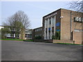
The Northicote High School
This school is now surrounded by a high metal fence. It used to be surrounded by a large open area.
Image: © Angella Streluk
Taken: 22 Apr 2006
0.13 miles
6
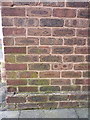
OS benchmark - Bushbury, 42 Primrose Avenue
An OS cutmark on the wall of a house on Primrose Avenue, originally levelled at 117.625m above Ordnance Datum Newlyn in 1963.
Image: © Richard Law
Taken: 1 Mar 2016
0.15 miles
7
Cavalier Crescent, Wolverhampton
Continuing the King Charles connection with Moseley Old Hall
Image: © Geoff Pick
Taken: 21 Apr 2009
0.17 miles
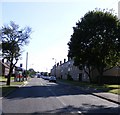
8
East end of Wychall Drive, Northwood Park
Seen from Cromwell Road.
Image: © Richard Vince
Taken: 24 Dec 2017
0.17 miles
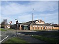
9
Time is running out for The King Charles
Marston's Brewery announced this week that they would be creating 1250 jobs in their 25 new pub restaurants to be opened next year. As their business model has changed to focus on food there is no longer a place for their large estate of tenanted locals many formerly trading under the original Banks's name. Marston's disposed of 388 pubs last year with a further 200 to go this year. The King Charles will be replaced by housing.
For a view as a going business see Image
Image: © John M
Taken: 6 Dec 2014
0.17 miles
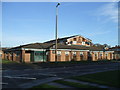
10
The King Charles in Cromwell Road
The king in this case will be Charles II who stayed nearby at Moseley Old Hall on his flight from the Battle of Worcester in 1651. The pub is a few hundred yards off the Monarch's Way footpath.
Typical Bank's modern estate public house similar to the Otter and Vixen Image
Image: © John M
Taken: 9 Feb 2008
0.19 miles