IMAGES TAKEN NEAR TO
Burnet Grove, WOLVERHAMPTON, WV10 7TT
Introduction
This page details the photographs taken nearby to Burnet Grove, WV10 7TT by members of the Geograph project.
The Geograph project started in 2005 with the aim of publishing, organising and preserving representative images for every square kilometre of Great Britain, Ireland and the Isle of Man.

There are currently over 7.5m images from over14,400 individuals and you can help contribute to the project by visiting https://www.geograph.org.uk
Image Map
Images are licensed for reuse under creativecommons.org/licenses/by-sa/2.0
Notes
- Clicking on the map will re-center to the selected point.
- The higher the marker number, the further away the image location is from the centre of the postcode.
Image Listing (9 Images Found)
Images are licensed for reuse under creativecommons.org/licenses/by-sa/2.0
Image
Details
Distance
3
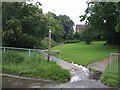
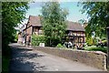
Footpath from Featherstone Hall Farm
Green space left among the new housing estate on the edge of the village.
Image: © John M
Taken: 22 Jul 2007
0.05 miles
4
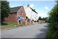
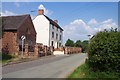
Featherstone Hall Farm
Traditional farmhouse on the edge of the expanded village.
Image: © John M
Taken: 22 Jul 2007
0.06 miles
5
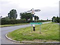
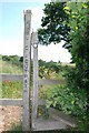
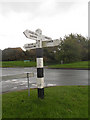
Featherstone Lane Sign
The view from the Finger Post down New Road.
Image: © Gordon Griffiths
Taken: 31 Aug 2012
0.07 miles