IMAGES TAKEN NEAR TO
Stafford Road, WOLVERHAMPTON, WV10 7PS
Introduction
This page details the photographs taken nearby to Stafford Road, WV10 7PS by members of the Geograph project.
The Geograph project started in 2005 with the aim of publishing, organising and preserving representative images for every square kilometre of Great Britain, Ireland and the Isle of Man.

There are currently over 7.5m images from over14,400 individuals and you can help contribute to the project by visiting https://www.geograph.org.uk
Image Map
Images are licensed for reuse under creativecommons.org/licenses/by-sa/2.0
Notes
- Clicking on the map will re-center to the selected point.
- The higher the marker number, the further away the image location is from the centre of the postcode.
Image Listing (25 Images Found)
Images are licensed for reuse under creativecommons.org/licenses/by-sa/2.0
Image
Details
Distance
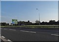
1
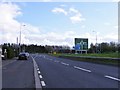
M54 Junction
The view towards Junction 2 on the M54 motorway with the Stafford Road at Wolverhampton.
Image: © Gordon Griffiths
Taken: 1 Apr 2017
0.02 miles
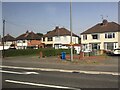
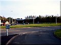
2
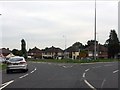
Semi-detached houses at the M54 junction
From the northwestern quadrant of the A449 roundabout.
Image: © J Whatley
Taken: 6 Sep 2010
0.05 miles
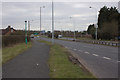
7
A449 entering Coven Heath
From M54 junction 2 roundabout
Image: © John Firth
Taken: 24 Jan 2015
0.09 miles
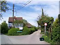
9
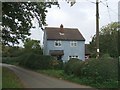
Blue Cottage
This blue cottage is in Ball Lane.
Image: © John M
Taken: 14 Oct 2006
0.11 miles
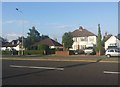
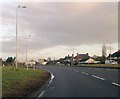
10
Junction 2
The M54 junction with the Stafford Road, Wolverhampton.
Image: © Gordon Griffiths
Taken: 16 Mar 2009
0.11 miles