IMAGES TAKEN NEAR TO
Little Saredon, WOLVERHAMPTON, WV10 7LQ
Introduction
This page details the photographs taken nearby to WV10 7LQ by members of the Geograph project.
The Geograph project started in 2005 with the aim of publishing, organising and preserving representative images for every square kilometre of Great Britain, Ireland and the Isle of Man.

There are currently over 7.5m images from over14,400 individuals and you can help contribute to the project by visiting https://www.geograph.org.uk
Image Map
Images are licensed for reuse under creativecommons.org/licenses/by-sa/2.0
Notes
- Clicking on the map will re-center to the selected point.
- The higher the marker number, the further away the image location is from the centre of the postcode.
Image Listing (7 Images Found)
Images are licensed for reuse under creativecommons.org/licenses/by-sa/2.0
Image
Details
Distance
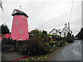
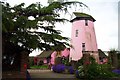
2
Little Saredon Windmill
On the market at £650 000.
Image: © John M
Taken: 6 Nov 2011
0.02 miles
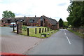
3
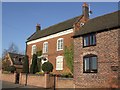
Little Saredon Dairy - Farmhouse
Grade II listed farmhouse dating from the early 18th century.
Image: © John M
Taken: 6 Nov 2011
0.03 miles
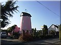
4
Little Saredon Windmill
Operated with sails until 1872 and steam driven until 1942. It is currently on the market at £650,000.
Image: © John M
Taken: 6 Nov 2011
0.03 miles
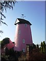
5
Little Saredon Windmill
Built before 1806, this mill worked by sail until the 1870s and by steam to about 1930. It was converted into a house in 1942 and further restored between 1976 and 1979. It had four sails and a boat cap.
Details from www.staffspasttrack.org.uk
Image: © Geoff Pick
Taken: 28 Apr 2006
0.04 miles
7
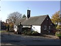
Lodge to Saredon Manor
A much modified and extended lodge building to the Grade II listed manor house.
Image: © John M
Taken: 6 Nov 2011
0.06 miles