IMAGES TAKEN NEAR TO
Great Saredon, WOLVERHAMPTON, WV10 7LL
Introduction
This page details the photographs taken nearby to WV10 7LL by members of the Geograph project.
The Geograph project started in 2005 with the aim of publishing, organising and preserving representative images for every square kilometre of Great Britain, Ireland and the Isle of Man.

There are currently over 7.5m images from over14,400 individuals and you can help contribute to the project by visiting https://www.geograph.org.uk
Image Map
Images are licensed for reuse under creativecommons.org/licenses/by-sa/2.0
Notes
- Clicking on the map will re-center to the selected point.
- The higher the marker number, the further away the image location is from the centre of the postcode.
Image Listing (21 Images Found)
Images are licensed for reuse under creativecommons.org/licenses/by-sa/2.0
Image
Details
Distance
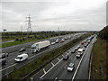
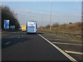
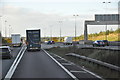
3
Power lines cross M6 junction 11a
Northbound M6 and M6 Toll converge beyond the bridge, which is in SJ950080 and connects Great Saredon and Little Saredon.
Image: © Robin Stott
Taken: 25 Sep 2010
0.07 miles
4
No time to be impatient
The junction of the M6 & M6 Toll. It's not nice to laugh in these situations but I'd just heard a 'Traffic Bulletin' that stated the length of this 'jam'. It went from here to J15 at Newcastle-u-Lyme. Tonight it was certainly quicker by train.
Image: © Row17
Taken: 15 Oct 2010
0.10 miles
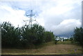
5
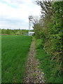
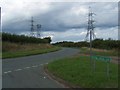
Field edge on Saredon Hill
Not a path as such, just a narrow strip of unplanted margin, but quite handy for unofficial access to the trig point on Saredon Hill. The phone mast is in Image, and provides phone coverage to the nearby junctions of the M6, M54 and M6 Toll motorways.
Image: © Richard Law
Taken: 2 May 2014
0.10 miles
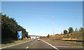
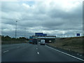
6
M6 Motorway - climbing to the M6 Toll
This section of the northbound carriageway is the only part of the M6 on its original alignment north of junction 11. Lane 3 takes an entirely different course, as outlined here: http://www.geograph.org.uk/photo/1630733.
Image: © Peter Whatley
Taken: 21 Jan 2011
0.15 miles
7
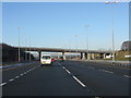
M6 At Junction 11a
This is the view from the toll road, with the extended slip from the M6 "ski jump" on the left and the main northbound access in cutting on the left. Note that on the right, the vast majority of traffic (normally 100% of HGVs) is staying on the (free) M6, rather than paying for the Toll Road.
Image: © Peter Whatley
Taken: 21 Dec 2009
0.16 miles
8
M6 southbound about to pass under M6 Toll road
Image: © Colin Pyle
Taken: 8 Sep 2011
0.18 miles
9
South Staffordshire : The M6 Motorway
The M6 Motorway heading through the South Staffordshire area.
Image: © Lewis Clarke
Taken: 29 Oct 2013
0.19 miles
10
Pylon by the M6 and M6 (Toll) motorways
Image: © N Chadwick
Taken: 17 Jul 2011
0.20 miles