IMAGES TAKEN NEAR TO
Saredon Road, WOLVERHAMPTON, WV10 7LF
Introduction
This page details the photographs taken nearby to Saredon Road, WV10 7LF by members of the Geograph project.
The Geograph project started in 2005 with the aim of publishing, organising and preserving representative images for every square kilometre of Great Britain, Ireland and the Isle of Man.

There are currently over 7.5m images from over14,400 individuals and you can help contribute to the project by visiting https://www.geograph.org.uk
Image Map
Images are licensed for reuse under creativecommons.org/licenses/by-sa/2.0
Notes
- Clicking on the map will re-center to the selected point.
- The higher the marker number, the further away the image location is from the centre of the postcode.
Image Listing (19 Images Found)
Images are licensed for reuse under creativecommons.org/licenses/by-sa/2.0
Image
Details
Distance
1
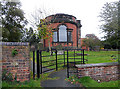
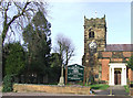
Church of St Mary and St Luke, Shareshill, Staffordshire
Image: © Roger D Kidd
Taken: 16 Jan 2008
0.19 miles
2
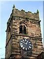
Tower and Clock, Church of St Mary and St Luke, Shareshill, Staffordshire
Church details: http://www.shares.force9.co.uk/
Image: © Roger D Kidd
Taken: 16 Jan 2008
0.20 miles
3

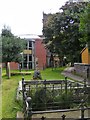
St Mary and St Luke's Churchyard, Shareshill, Staffordshire
Church details: http://www.shares.force9.co.uk/
Image: © Roger D Kidd
Taken: 16 Jan 2008
0.20 miles
4
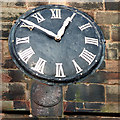
Church Clock, Shareshill, Staffordshire
The remains of an older clock have been partly obliterated by the large clockface, which appears to have been targeted by an air rifle prankster.
Image: © Roger D Kidd
Taken: 16 Jan 2008
0.20 miles
5
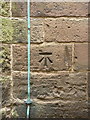
OS benchmark - Shareshill, church tower
A clear & distinct benchmark at the base of the church tower; originally levelled at 139.583m above Ordnance Datum Newlyn.
Image: © Richard Law
Taken: 24 Jun 2014
0.20 miles
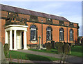
7
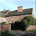
Monks Cottage, Shareshill, Staffordshire
This is part of an extensively restored group including Manor Farm, the Malthouse and some barns. This web-page http://www.british-history.ac.uk/report.aspx?compid=53409 includes this information: Manor Farm contains in its south half a well preserved early-17th-century house with attics and a central chimney-stack.
Image: © Roger D Kidd
Taken: 16 Jan 2008
0.20 miles
8
Church of St Mary and St Luke, Shareshill, Staffordshire
The 13th century tower is the finest part of the church architecturally, the sections added in later centuries being visually "unsympathetic". The interior does boast some attractive qualities however (see http://www.shares.force9.co.uk for details of the church and village generally). A public footpath passes to the left of the tower and leads across the fields towards Latherford Farm.
Image: © Roger D Kidd
Taken: 16 Jan 2008
0.21 miles
9
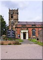
Shareshill Church
The Church of St Mary and St Luke with its 13th century tower stands off Church Road in the Staffordshire village.
Image: © Gordon Griffiths
Taken: 31 Aug 2012
0.21 miles