IMAGES TAKEN NEAR TO
Old Cannock Road, WOLVERHAMPTON, WV10 7JQ
Introduction
This page details the photographs taken nearby to Old Cannock Road, WV10 7JQ by members of the Geograph project.
The Geograph project started in 2005 with the aim of publishing, organising and preserving representative images for every square kilometre of Great Britain, Ireland and the Isle of Man.

There are currently over 7.5m images from over14,400 individuals and you can help contribute to the project by visiting https://www.geograph.org.uk
Image Map
Images are licensed for reuse under creativecommons.org/licenses/by-sa/2.0
Notes
- Clicking on the map will re-center to the selected point.
- The higher the marker number, the further away the image location is from the centre of the postcode.
Image Listing (18 Images Found)
Images are licensed for reuse under creativecommons.org/licenses/by-sa/2.0
Image
Details
Distance
2
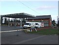
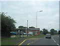
New use for filling station
Baths and taps have replaced petrol at this former filling station on the Wolverhampton to Cannock road.
Image: © John M
Taken: 27 Jan 2008
0.02 miles
4
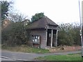
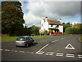
Leaning bus shelter
At the edge of the village on the Wolverhampton to Cannock road.
Image: © John M
Taken: 27 Jan 2008
0.03 miles
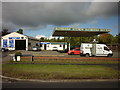
9
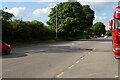
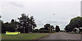
A460 Cannock Road looking northwards
Image: © Christopher Hilton
Taken: 6 Jun 2021
0.13 miles
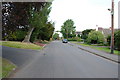
10
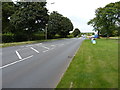
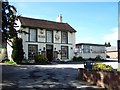
A460 Cannock Road at Shareshill
Scene right outside the large truck fuel-stop at Shareshill.
Image: © Richard Law
Taken: 4 Aug 2014
0.14 miles