IMAGES TAKEN NEAR TO
Wood Lane, WOLVERHAMPTON, WV10 7FD
Introduction
This page details the photographs taken nearby to Wood Lane, WV10 7FD by members of the Geograph project.
The Geograph project started in 2005 with the aim of publishing, organising and preserving representative images for every square kilometre of Great Britain, Ireland and the Isle of Man.

There are currently over 7.5m images from over14,400 individuals and you can help contribute to the project by visiting https://www.geograph.org.uk
Image Map
Images are licensed for reuse under creativecommons.org/licenses/by-sa/2.0
Notes
- Clicking on the map will re-center to the selected point.
- The higher the marker number, the further away the image location is from the centre of the postcode.
Image Listing (7 Images Found)
Images are licensed for reuse under creativecommons.org/licenses/by-sa/2.0
Image
Details
Distance
2
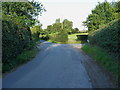
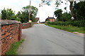
Junction in Great Saredon
The junction of Windy Arbour Lane with Boulton Lane, in the village.
Image: © Richard Law
Taken: 13 Aug 2014
0.04 miles
4
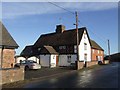
High View Cottage
Extended property at a road junction in Great Saredon village.
Image: © John M
Taken: 12 Jan 2008
0.17 miles
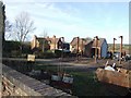
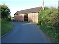
7
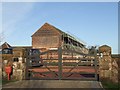
Barn conversion at Saredon Hall Farm
The three barn conversions are on offer at around £650,000 each. A bit noisy as there is a continuous traffic noise from the nearby M6 and M6 Toll.
Image: © John M
Taken: 12 Jan 2008
0.25 miles