IMAGES TAKEN NEAR TO
Laches Close, WOLVERHAMPTON, WV10 7DZ
Introduction
This page details the photographs taken nearby to Laches Close, WV10 7DZ by members of the Geograph project.
The Geograph project started in 2005 with the aim of publishing, organising and preserving representative images for every square kilometre of Great Britain, Ireland and the Isle of Man.

There are currently over 7.5m images from over14,400 individuals and you can help contribute to the project by visiting https://www.geograph.org.uk
Image Map
Images are licensed for reuse under creativecommons.org/licenses/by-sa/2.0
Notes
- Clicking on the map will re-center to the selected point.
- The higher the marker number, the further away the image location is from the centre of the postcode.
Image Listing (8 Images Found)
Images are licensed for reuse under creativecommons.org/licenses/by-sa/2.0
Image
Details
Distance
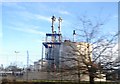
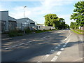
3
A sign of the times, Four Ashes Industrial estate
Image: © Mick Malpass
Taken: 11 Jun 2011
0.14 miles
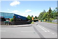
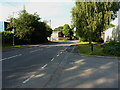
4
Four Ashes Industrial Estate
Near the western side of the Four Ashes Industrial Estate.
Image: © Richard Law
Taken: 21 Jul 2014
0.14 miles
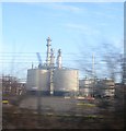
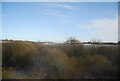
6
Four Ashes Industrial Estate
The eastern side of a small light-industrial estate just off the A449 Stafford to Wolverhampton road.
Image: © Richard Law
Taken: 21 Jul 2014
0.20 miles
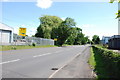
7
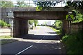
Railway Bridge near Four Ashes Industrial Estate
Image: © Geoff Pick
Taken: 5 Jun 2006
0.20 miles