IMAGES TAKEN NEAR TO
Cannock Road, WOLVERHAMPTON, WV10 7AG
Introduction
This page details the photographs taken nearby to Cannock Road, WV10 7AG by members of the Geograph project.
The Geograph project started in 2005 with the aim of publishing, organising and preserving representative images for every square kilometre of Great Britain, Ireland and the Isle of Man.

There are currently over 7.5m images from over14,400 individuals and you can help contribute to the project by visiting https://www.geograph.org.uk
Image Map
Images are licensed for reuse under creativecommons.org/licenses/by-sa/2.0
Notes
- Clicking on the map will re-center to the selected point.
- The higher the marker number, the further away the image location is from the centre of the postcode.
Image Listing (5 Images Found)
Images are licensed for reuse under creativecommons.org/licenses/by-sa/2.0
Image
Details
Distance
1
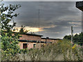
ROF (Royal Ordnance Factory) Featherstone
The old wartime ammunitions factory, now slowly being demolished.
Image: © paul hunt
Taken: 19 Aug 2008
0.02 miles
2
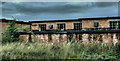
ROF (Royal Ordnance Factory) Featherstone
Disused wartime ammunitions factory now being slowly demolished.
Image: © paul hunt
Taken: 19 Aug 2008
0.02 miles
3
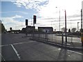
Cannock Road Lights
The view in Featherstone, Staffordshire.
Image: © Gordon Griffiths
Taken: 4 May 2013
0.07 miles
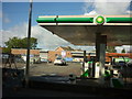
4
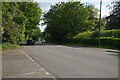
A460 Cannock Road looking southwards
Image: © Christopher Hilton
Taken: 6 Jun 2021
0.22 miles